Wischhafen geodata
Wischhafen (Lower Saxony) is a seat of a fourth-order administrative division; located in Germany in Europe/Berlin (GMT+2) time zone. With population of 3,110 people, there are 3908 cities with bigger population in this country. Compared to other cities in Germany, 89.8% of cities are located further ↓South; 60.6% of cities are located further →East and 99.5% of cities have higher elevation than Wischhafen. Note1


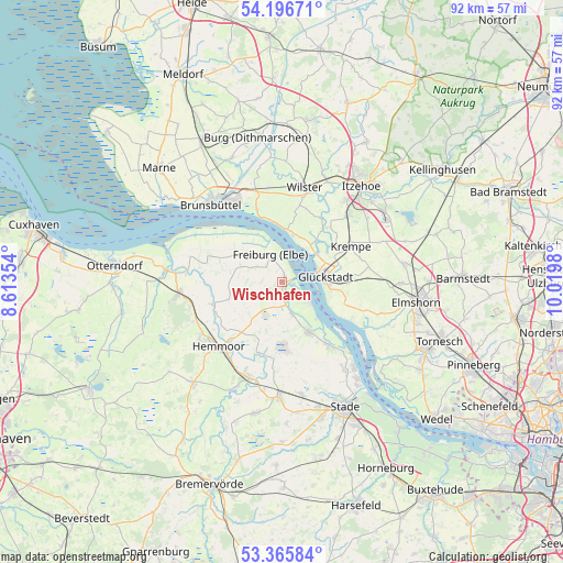
Wischhafen GPS coordinates[2]
53° 46' 59.988" North, 9° 19' 0.012" East
| Map corner | latitude | longitude |
|---|---|---|
| Upper-left | 54.19671°, | 8.61354° |
| Center: | 53.78333°, | 9.31667° |
| Lower-right: | 53.36584°, | 10.0198° |
| Map W x H: | 92.4×92.4 km | = 57.4×57.4mi |
| max Lat: | 55.01917° ⇑10.2% North |
| Wischhafen: | 53.78333° |
| min Lat: | ⇓89.8% South 47.40724° |
| min Long | Wischhafen | max Long |
| 5.92978° | 9.31667° | 14.98853° |
| W 39.4%⇐ | ⇒60.6% E |
Elevation
Elevation of Wischhafen is -1 m = -3 ft, and this is 250.1 m = 821 ft below average elevation for this country.
| Max E: |
1256 m = 4121 ft | 99.5% |
| Avg. | 249.1 m = 817 ft | |
| Wischhafen | -1 m = -3 ft | |
Min E: |
-5 m = -16 ft | 0.5% |
See also: Germany elevation on elevation.city.
Geographical zone
Wischhafen is located in North temperate zone (between Tropic of Cancer and the Arctic Circle). Distance of this North polar circle is 1421 km =883 mi to North.| Distance of | km | miles | from Wischhafen |
|---|---|---|---|
| North Pole | 4026.9 | 2502.2 | to North |
| Arctic Circle | 1421 | 883 | to North |
| Tropic Cancer | 3374.2 | 2096.6 | to South |
| Equator | 5980.1 | 3715.9 | to South |


Nearby cities:
15 places around Wischhafen: (largest is in red/bold)
• Blomesche Wildnis
6.8 km =4.2 mi,  74°
74°
• Borsfleth
9.5 km =5.9 mi,  54°
54°
• Brokdorf
9 km =5.6 mi,  2°
2°
• Drochtersen
9.3 km =5.8 mi,  151°
151°
• Elskop
11.6 km =7.2 mi, 71°
• Freiburg
5 km =3.1 mi,  338°
338°
• Glückstadt
7.2 km =4.5 mi,  85°
85°
• Großenwörden
11.6 km =7.2 mi,  196°
196°
• Herzhorn
10.9 km =6.8 mi, 90°
• Krempdorf
11.3 km =7 mi,  60°
60°
• Krummendeich
9.1 km =5.7 mi,  305°
305°
• Oberndorf
11.6 km =7.2 mi,  251°
251°
• Oederquart
5.7 km =3.5 mi,  292°
292°
• Osten
12 km =7.5 mi,  219°
219°
• Wewelsfleth
9.2 km =5.7 mi,  36°
36°
Sources, notices
• [Note1] Compared only with cities in Germany existing in our database
• [Src1] Map data: © OpenStreetMap contributors (CC-BY-SA)
• [Src2] Other city data from geonames.org with taken over terms of usage.
• [Src3] Geographical zone / Annual Mean Temperature by Robert A. Rohde @ Wikipedia
