Gleiritsch geodata
Gleiritsch (Bavaria) is a seat of a fourth-order administrative division; located in Germany in Europe/Berlin (GMT+2) time zone. With population of 687 people, there are 8378 cities with bigger population in this country. Compared to other cities in Germany, 75.8% of cities are located further ↑North; 85.9% of cities are located further ←West and 88.3% of cities have lower elevation than Gleiritsch. Note1
Administrative division(s):
- Level 1: Bavaria
- Level 2: Upper Palatinate
- Level 3: Landkreis Schwandorf
- Level 4: Gleiritsch


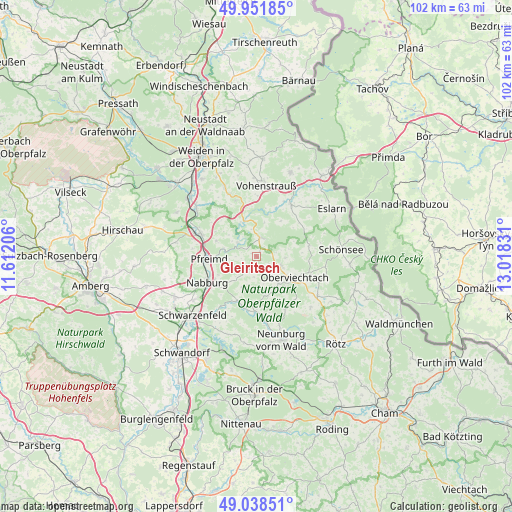
Gleiritsch GPS coordinates[2]
49° 29' 50.316" North, 12° 18' 54.648" East
| Map corner | latitude | longitude |
|---|---|---|
| Upper-left | 49.95185°, | 11.61206° |
| Center: | 49.49731°, | 12.31518° |
| Lower-right: | 49.03851°, | 13.01831° |
| Map W x H: | 101.6×101.6 km | = 63.1×63.1mi |
| max Lat: | 55.01917° ⇑75.8% North |
| Gleiritsch: | 49.49731° |
| min Lat: | ⇓24.2% South 47.40724° |
| min Long | Gleiritsch | max Long |
| 5.92978° | 12.31518° | 14.98853° |
| W 85.9%⇐ | ⇒14.1% E |
Elevation
Elevation of Gleiritsch is 496 m = 1627 ft, and this is 246.9 m = 810 ft above average elevation for this country.
| Max E: |
1256 m = 4121 ft | 11.7% |
| Gleiritsch | 496 m 1627 ft | |
| Avg. | 249.1 m = 817 ft | |
Min E: |
-5 m = -16 ft | 88.3% |
See also: Germany elevation on elevation.city.
Geographical zone
Gleiritsch is located in North temperate zone (between Tropic of Cancer and the Arctic Circle). Distance of this North polar circle is 1897.6 km =1179.1 mi to North.| Distance of | km | miles | from Gleiritsch |
|---|---|---|---|
| North Pole | 4503.5 | 2798.3 | to North |
| Arctic Circle | 1897.6 | 1179.1 | to North |
| Tropic Cancer | 2897.7 | 1800.5 | to South |
| Equator | 5503.6 | 3419.8 | to South |


Nearby cities:
15 places around Gleiritsch: (largest is in red/bold)
• Altendorf
10.5 km =6.5 mi,  193°
193°
• Bach
11.9 km =7.4 mi,  155°
155°
• Dieterskirchen
11.6 km =7.2 mi,  140°
140°
• Guteneck
5.7 km =3.5 mi,  203°
203°
• Leuchtenberg
11.9 km =7.4 mi,  339°
339°
• Moosbach
12.3 km =7.6 mi,  33°
33°
• Nabburg
10.9 km =6.8 mi,  243°
243°
• Niedermurach
6.9 km =4.3 mi, 140°
• Oberviechtach
8.5 km =5.3 mi,  120°
120°
• Pfreimd
9.7 km =6 mi,  265°
265°
• Schwarzhofen
13.5 km =8.4 mi,  170°
170°
• Teunz
5.2 km =3.2 mi,  107°
107°
• Trausnitz
4.6 km =2.9 mi,  304°
304°
• Tännesberg
3.9 km =2.4 mi,  13°
13°
• Wernberg-Köblitz
12 km =7.5 mi,  292°
292°
Sources, notices
• [Note1] Compared only with cities in Germany existing in our database
• [Src1] Map data: © OpenStreetMap contributors (CC-BY-SA)
• [Src2] Other city data from geonames.org with taken over terms of usage.
• [Src3] Geographical zone / Annual Mean Temperature by Robert A. Rohde @ Wikipedia
