Bach geodata
Bach (Bavaria) is a populated place; located in Germany in Europe/Berlin (GMT+2) time zone. With population of 1,759 people, there are 5413 cities with bigger population in this country. Compared to other cities in Germany, 77.2% of cities are located further ↑North; 86.8% of cities are located further ←West and 86.2% of cities have lower elevation than Bach. Note1
Administrative division(s):
- Level 1: Bavaria
- Level 2: Upper Palatinate
- Level 3: Landkreis Schwandorf
- Level 4: Dieterskirchen


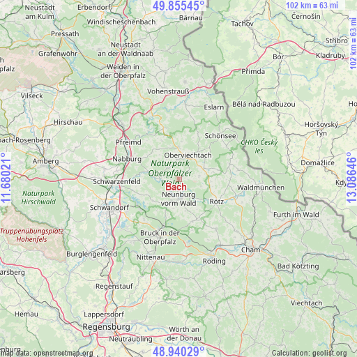
Bach GPS coordinates[2]
49° 24' 0" North, 12° 22' 59.988" East
| Map corner | latitude | longitude |
|---|---|---|
| Upper-left | 49.85545°, | 11.68021° |
| Center: | 49.4°, | 12.38333° |
| Lower-right: | 48.94029°, | 13.08646° |
| Map W x H: | 101.8×101.8 km | = 63.3×63.3mi |
| max Lat: | 55.01917° ⇑77.2% North |
| Bach: | 49.4° |
| min Lat: | ⇓22.8% South 47.40724° |
| min Long | Bach | max Long |
| 5.92978° | 12.38333° | 14.98853° |
| W 86.8%⇐ | ⇒13.2% E |
Elevation
Elevation of Bach is 479 m = 1572 ft, and this is 229.9 m = 754 ft above average elevation for this country.
| Max E: |
1256 m = 4121 ft | 13.8% |
| Bach | 479 m 1572 ft | |
| Avg. | 249.1 m = 817 ft | |
Min E: |
-5 m = -16 ft | 86.2% |
See also: Germany elevation on elevation.city.
Geographical zone
Bach is located in North temperate zone (between Tropic of Cancer and the Arctic Circle). Distance of this North polar circle is 1908.4 km =1185.8 mi to North.| Distance of | km | miles | from Bach |
|---|---|---|---|
| North Pole | 4514.3 | 2805.1 | to North |
| Arctic Circle | 1908.4 | 1185.8 | to North |
| Tropic Cancer | 2886.8 | 1793.8 | to South |
| Equator | 5492.8 | 3413.1 | to South |


Nearby cities:
15 places around Bach: (largest is in red/bold)
• Altendorf
7.4 km =4.6 mi,  274°
274°
• Dieterskirchen
3 km =1.9 mi,  52°
52°
• Gleiritsch
11.9 km =7.4 mi,  335°
335°
• Guteneck
9.1 km =5.7 mi,  307°
307°
• Neukirchen-Balbini
12.7 km =7.9 mi,  162°
162°
• Neunburg vorm Wald
5.8 km =3.6 mi,  177°
177°
• Niedermurach
5.6 km =3.5 mi,  354°
354°
• Oberviechtach
6.9 km =4.3 mi,  20°
20°
• Pettendorf
5.3 km =3.3 mi,  199°
199°
• Rötz
12.3 km =7.6 mi,  120°
120°
• Schwarzhofen
3.7 km =2.3 mi,  228°
228°
• Teunz
9.3 km =5.8 mi,  0°
0°
• Thanstein
6.3 km =3.9 mi,  107°
107°
• Tiefenbach
14.9 km =9.3 mi,  75°
75°
• Winklarn
7.6 km =4.7 mi,  66°
66°
Sources, notices
• [Note1] Compared only with cities in Germany existing in our database
• [Src1] Map data: © OpenStreetMap contributors (CC-BY-SA)
• [Src2] Other city data from geonames.org with taken over terms of usage.
• [Src3] Geographical zone / Annual Mean Temperature by Robert A. Rohde @ Wikipedia
