Gesees geodata
Gesees (Bavaria) is a populated place; located in Germany in Europe/Berlin (GMT+2) time zone. With population of 1,244 people, there are 6463 cities with bigger population in this country. Compared to other cities in Germany, 63% of cities are located further ↑North; 76.7% of cities are located further ←West and 79.1% of cities have lower elevation than Gesees. Note1
Administrative division(s):
- Level 1: Bavaria
- Level 2: Upper Franconia
- Level 3: Landkreis Bayreuth
- Level 4: Bad Berneck i.Fichtelgebirge


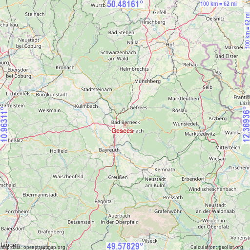
Gesees GPS coordinates[2]
50° 1' 55.452" North, 11° 39' 58.428" East
| Map corner | latitude | longitude |
|---|---|---|
| Upper-left | 50.48161°, | 10.96311° |
| Center: | 50.03207°, | 11.66623° |
| Lower-right: | 49.57829°, | 12.36936° |
| Map W x H: | 100.4×100.4 km | = 62.4×62.4mi |
| max Lat: | 55.01917° ⇑63% North |
| Gesees: | 50.03207° |
| min Lat: | ⇓37% South 47.40724° |
| min Long | Gesees | max Long |
| 5.92978° | 11.66623° | 14.98853° |
| W 76.7%⇐ | ⇒23.3% E |
Elevation
Elevation of Gesees is 428 m = 1404 ft, and this is 178.9 m = 587 ft above average elevation for this country.
| Max E: |
1256 m = 4121 ft | 20.9% |
| Gesees | 428 m 1404 ft | |
| Avg. | 249.1 m = 817 ft | |
Min E: |
-5 m = -16 ft | 79.1% |
See also: Germany elevation on elevation.city.
Geographical zone
Gesees is located in North temperate zone (between Tropic of Cancer and the Arctic Circle). Distance of this North polar circle is 1838.1 km =1142.1 mi to North.| Distance of | km | miles | from Gesees |
|---|---|---|---|
| North Pole | 4444 | 2761.4 | to North |
| Arctic Circle | 1838.1 | 1142.1 | to North |
| Tropic Cancer | 2957.1 | 1837.5 | to South |
| Equator | 5563 | 3456.7 | to South |


Nearby cities:
15 places around Gesees: (largest is in red/bold)
• Bad Berneck im Fichtelgebirge
1.6 km =1 mi,  16°
16°
• Bayreuth
11.3 km =7 mi,  213°
213°
• Bindlach
6.7 km =4.2 mi, 213°
• Bischofsgrün
9.8 km =6.1 mi,  77°
77°
• Gefrees
8.7 km =5.4 mi,  35°
35°
• Goldkronach
2.8 km =1.7 mi,  147°
147°
• Harsdorf
7.1 km =4.4 mi,  271°
271°
• Heinersreuth
12 km =7.5 mi,  232°
232°
• Himmelkron
6.1 km =3.8 mi,  309°
309°
• Marktschorgast
7 km =4.3 mi,  353°
353°
• Neuenmarkt
9 km =5.6 mi,  317°
317°
• Reuth
5.1 km =3.2 mi,  156°
156°
• Trebgast
9.1 km =5.7 mi,  294°
294°
• Warmensteinach
9.1 km =5.7 mi,  118°
118°
• Wirsberg
9.3 km =5.8 mi,  331°
331°
Sources, notices
• [Note1] Compared only with cities in Germany existing in our database
• [Src1] Map data: © OpenStreetMap contributors (CC-BY-SA)
• [Src2] Other city data from geonames.org with taken over terms of usage.
• [Src3] Geographical zone / Annual Mean Temperature by Robert A. Rohde @ Wikipedia
