Gersthofen geodata
Gersthofen (Bavaria) is a populated place; located in Germany in Europe/Berlin (GMT+2) time zone. With population of 20,254 people, there are 763 cities with bigger population in this country. Compared to other cities in Germany, 90% of cities are located further ↑North; 65.1% of cities are located further ←West and 85.5% of cities have lower elevation than Gersthofen. Note1
Administrative division(s):
- Level 1: Bavaria
- Level 2: Swabia
- Level 3: Landkreis Augsburg
- Level 4: Gersthofen


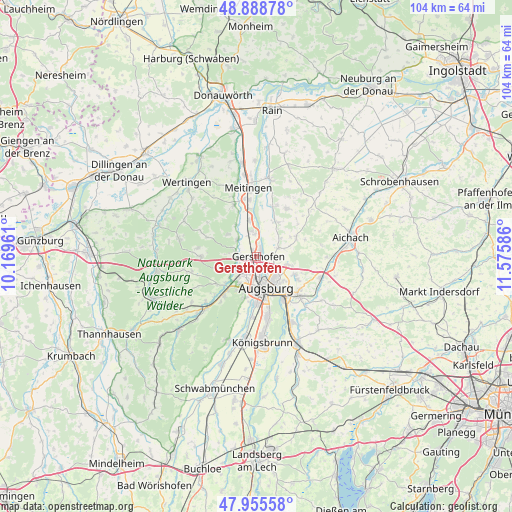
Gersthofen GPS coordinates[2]
48° 25' 27.552" North, 10° 52' 21.828" East
| Map corner | latitude | longitude |
|---|---|---|
| Upper-left | 48.88878°, | 10.16961° |
| Center: | 48.42432°, | 10.87273° |
| Lower-right: | 47.95558°, | 11.57586° |
| Map W x H: | 103.8×103.8 km | = 64.5×64.5mi |
| max Lat: | 55.01917° ⇑90% North |
| Gersthofen: | 48.42432° |
| min Lat: | ⇓10% South 47.40724° |
| min Long | Gersthofen | max Long |
| 5.92978° | 10.87273° | 14.98853° |
| W 65.1%⇐ | ⇒34.9% E |
Elevation
Elevation of Gersthofen is 473 m = 1552 ft, and this is 223.9 m = 735 ft above average elevation for this country.
| Max E: |
1256 m = 4121 ft | 14.5% |
| Gersthofen | 473 m 1552 ft | |
| Avg. | 249.1 m = 817 ft | |
Min E: |
-5 m = -16 ft | 85.5% |
See also: Germany elevation on elevation.city.
Geographical zone
Gersthofen is located in North temperate zone (between Tropic of Cancer and the Arctic Circle). Distance of this North polar circle is 2016.9 km =1253.2 mi to North.| Distance of | km | miles | from Gersthofen |
|---|---|---|---|
| North Pole | 4622.8 | 2872.5 | to North |
| Arctic Circle | 2016.9 | 1253.2 | to North |
| Tropic Cancer | 2778.4 | 1726.4 | to South |
| Equator | 5384.3 | 3345.6 | to South |


Nearby cities:
15 places around Gersthofen: (largest is in red/bold)
• Adelsried
11.4 km =7.1 mi,  270°
270°
• Affing
9.4 km =5.8 mi,  60°
60°
• Aindling
11.6 km =7.2 mi,  30°
30°
• Augsburg
6.2 km =3.9 mi,  162°
162°
• Aystetten
7.3 km =4.5 mi,  253°
253°
• Biberbach
11.3 km =7 mi,  336°
336°
• Bonstetten
12.5 km =7.8 mi,  278°
278°
• Diedorf
10.4 km =6.5 mi,  220°
220°
• Friedberg
11.2 km =7 mi,  132°
132°
• Gablingen
5 km =3.1 mi,  304°
304°
• Heretsried
10.8 km =6.7 mi,  291°
291°
• Langweid
7.5 km =4.7 mi,  348°
348°
• Rehling
7.9 km =4.9 mi, 34°
• Stadtbergen
6.7 km =4.2 mi,  196°
196°
• Todtenweis
11.1 km =6.9 mi,  21°
21°
Sources, notices
• [Note1] Compared only with cities in Germany existing in our database
• [Src1] Map data: © OpenStreetMap contributors (CC-BY-SA)
• [Src2] Other city data from geonames.org with taken over terms of usage.
• [Src3] Geographical zone / Annual Mean Temperature by Robert A. Rohde @ Wikipedia
