Gablingen geodata
Gablingen (Bavaria) is a seat of a fourth-order administrative division; located in Germany in Europe/Berlin (GMT+2) time zone. With population of 4,707 people, there are 2937 cities with bigger population in this country. Compared to other cities in Germany, 89.7% of cities are located further ↑North; 64.3% of cities are located further ←West and 84.7% of cities have lower elevation than Gablingen. Note1
Administrative division(s):
- Level 1: Bavaria
- Level 2: Swabia
- Level 3: Landkreis Augsburg
- Level 4: Gablingen


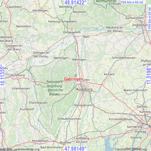
Gablingen GPS coordinates[2]
48° 27' 0" North, 10° 49' 0.012" East
| Map corner | latitude | longitude |
|---|---|---|
| Upper-left | 48.91422°, | 10.11355° |
| Center: | 48.45°, | 10.81667° |
| Lower-right: | 47.98149°, | 11.5198° |
| Map W x H: | 103.7×103.7 km | = 64.4×64.4mi |
| max Lat: | 55.01917° ⇑89.7% North |
| Gablingen: | 48.45° |
| min Lat: | ⇓10.3% South 47.40724° |
| min Long | Gablingen | max Long |
| 5.92978° | 10.81667° | 14.98853° |
| W 64.3%⇐ | ⇒35.7% E |
Elevation
Elevation of Gablingen is 466 m = 1529 ft, and this is 216.9 m = 712 ft above average elevation for this country.
| Max E: |
1256 m = 4121 ft | 15.3% |
| Gablingen | 466 m 1529 ft | |
| Avg. | 249.1 m = 817 ft | |
Min E: |
-5 m = -16 ft | 84.7% |
See also: Germany elevation on elevation.city.
Geographical zone
Gablingen is located in North temperate zone (between Tropic of Cancer and the Arctic Circle). Distance of this North polar circle is 2014 km =1251.4 mi to North.| Distance of | km | miles | from Gablingen |
|---|---|---|---|
| North Pole | 4619.9 | 2870.7 | to North |
| Arctic Circle | 2014 | 1251.4 | to North |
| Tropic Cancer | 2781.2 | 1728.2 | to South |
| Equator | 5387.1 | 3347.4 | to South |


Nearby cities:
15 places around Gablingen: (largest is in red/bold)
• Adelsried
7.8 km =4.8 mi,  248°
248°
• Augsburg
10.6 km =6.6 mi,  145°
145°
• Aystetten
5.7 km =3.5 mi,  210°
210°
• Biberbach
7.5 km =4.7 mi,  357°
357°
• Bonstetten
8.3 km =5.2 mi,  262°
262°
• Diedorf
11.1 km =6.9 mi,  193°
193°
• Emersacker
11.4 km =7.1 mi,  292°
292°
• Gersthofen
5 km =3.1 mi,  124°
124°
• Heretsried
6 km =3.7 mi,  280°
280°
• Langweid
5.3 km =3.3 mi,  30°
30°
• Meitingen
11 km =6.8 mi,  13°
13°
• Rehling
9.4 km =5.8 mi,  66°
66°
• Stadtbergen
9.5 km =5.9 mi,  166°
166°
• Todtenweis
11.1 km =6.9 mi,  47°
47°
• Welden
11.5 km =7.1 mi,  272°
272°
Sources, notices
• [Note1] Compared only with cities in Germany existing in our database
• [Src1] Map data: © OpenStreetMap contributors (CC-BY-SA)
• [Src2] Other city data from geonames.org with taken over terms of usage.
• [Src3] Geographical zone / Annual Mean Temperature by Robert A. Rohde @ Wikipedia
