Todtenweis geodata
Todtenweis (Bavaria) is a seat of a fourth-order administrative division; located in Germany in Europe/Berlin (GMT+2) time zone. With population of 1,443 people, there are 5996 cities with bigger population in this country. Compared to other cities in Germany, 89% of cities are located further ↑North; 65.9% of cities are located further ←West and 82.3% of cities have lower elevation than Todtenweis. Note1
Administrative division(s):
- Level 1: Bavaria
- Level 2: Swabia
- Level 3: Landkreis Aichach-Friedberg
- Level 4: Todtenweis


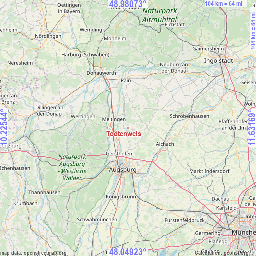
Todtenweis GPS coordinates[2]
48° 31' 1.632" North, 10° 55' 42.816" East
| Map corner | latitude | longitude |
|---|---|---|
| Upper-left | 48.98073°, | 10.22544° |
| Center: | 48.51712°, | 10.92856° |
| Lower-right: | 48.04923°, | 11.63169° |
| Map W x H: | 103.6×103.6 km | = 64.4×64.4mi |
| max Lat: | 55.01917° ⇑89% North |
| Todtenweis: | 48.51712° |
| min Lat: | ⇓11% South 47.40724° |
| min Long | Todtenweis | max Long |
| 5.92978° | 10.92856° | 14.98853° |
| W 65.9%⇐ | ⇒34.1% E |
Elevation
Elevation of Todtenweis is 448 m = 1470 ft, and this is 198.9 m = 653 ft above average elevation for this country.
| Max E: |
1256 m = 4121 ft | 17.7% |
| Todtenweis | 448 m 1470 ft | |
| Avg. | 249.1 m = 817 ft | |
Min E: |
-5 m = -16 ft | 82.3% |
See also: Germany elevation on elevation.city.
Geographical zone
Todtenweis is located in North temperate zone (between Tropic of Cancer and the Arctic Circle). Distance of this North polar circle is 2006.6 km =1246.8 mi to North.| Distance of | km | miles | from Todtenweis |
|---|---|---|---|
| North Pole | 4612.5 | 2866.1 | to North |
| Arctic Circle | 2006.6 | 1246.8 | to North |
| Tropic Cancer | 2788.7 | 1732.8 | to South |
| Equator | 5394.6 | 3352 | to South |


Nearby cities:
15 places around Todtenweis: (largest is in red/bold)
• Affing
6.9 km =4.3 mi,  144°
144°
• Aindling
1.9 km =1.2 mi,  102°
102°
• Biberbach
8.6 km =5.3 mi,  270°
270°
• Ellgau
10.3 km =6.4 mi,  333°
333°
• Gablingen
11.1 km =6.9 mi,  227°
227°
• Gersthofen
11.1 km =6.9 mi,  201°
201°
• Hollenbach
10.8 km =6.7 mi,  110°
110°
• Holzheim
10.6 km =6.6 mi,  7°
7°
• Kühlenthal
9.9 km =6.2 mi,  303°
303°
• Langweid
6.3 km =3.9 mi,  242°
242°
• Meitingen
6.5 km =4 mi, 299°
• Petersdorf
7.7 km =4.8 mi,  90°
90°
• Rehling
3.8 km =2.4 mi,  174°
174°
• Thierhaupten
5.6 km =3.5 mi,  344°
344°
• Westendorf
8.9 km =5.5 mi,  313°
313°
Sources, notices
• [Note1] Compared only with cities in Germany existing in our database
• [Src1] Map data: © OpenStreetMap contributors (CC-BY-SA)
• [Src2] Other city data from geonames.org with taken over terms of usage.
• [Src3] Geographical zone / Annual Mean Temperature by Robert A. Rohde @ Wikipedia
