Geroda geodata
Geroda (Thuringia) is a seat of a fourth-order administrative division; located in Germany in Europe/Berlin (GMT+2) time zone. With population of 274 people, there are 10151 cities with bigger population in this country. Compared to other cities in Germany, 53.5% of cities are located further ↓South; 80.3% of cities are located further ←West and 69.3% of cities have lower elevation than Geroda. Note1


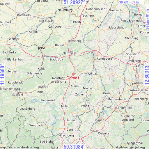
Geroda GPS coordinates[2]
50° 46' 0.012" North, 11° 54' 0" East
| Map corner | latitude | longitude |
|---|---|---|
| Upper-left | 51.20927°, | 11.19688° |
| Center: | 50.76667°, | 11.9° |
| Lower-right: | 50.31984°, | 12.60313° |
| Map W x H: | 98.9×98.9 km | = 61.5×61.5mi |
| max Lat: | 55.01917° ⇑46.5% North |
| Geroda: | 50.76667° |
| min Lat: | ⇓53.5% South 47.40724° |
| min Long | Geroda | max Long |
| 5.92978° | 11.9° | 14.98853° |
| W 80.3%⇐ | ⇒19.7% E |
Elevation
Elevation of Geroda is 353 m = 1158 ft, and this is 103.9 m = 341 ft above average elevation for this country.
| Max E: |
1256 m = 4121 ft | 30.7% |
| Geroda | 353 m 1158 ft | |
| Avg. | 249.1 m = 817 ft | |
Min E: |
-5 m = -16 ft | 69.3% |
See also: Germany elevation on elevation.city.
Geographical zone
Geroda is located in North temperate zone (between Tropic of Cancer and the Arctic Circle). Distance of this North polar circle is 1756.4 km =1091.4 mi to North.| Distance of | km | miles | from Geroda |
|---|---|---|---|
| North Pole | 4362.3 | 2710.6 | to North |
| Arctic Circle | 1756.4 | 1091.4 | to North |
| Tropic Cancer | 3038.8 | 1888.2 | to South |
| Equator | 5644.7 | 3507.5 | to South |


Nearby cities:
15 places around Geroda: (largest is in red/bold)
• Auma
7.4 km =4.6 mi,  180°
180°
• Bocka
7.3 km =4.5 mi,  40°
40°
• Eineborn
7.8 km =4.8 mi,  342°
342°
• Karlsdorf
7.9 km =4.9 mi,  297°
297°
• Kleinebersdorf
7.3 km =4.5 mi,  319°
319°
• Lederhose
3.9 km =2.4 mi,  17°
17°
• Lemnitz
6.9 km =4.3 mi,  223°
223°
• Miesitz
6 km =3.7 mi,  231°
231°
• Mittelpöllnitz
2.2 km =1.4 mi,  147°
147°
• Münchenbernsdorf
6.5 km =4 mi, 20°
• Renthendorf
5.2 km =3.2 mi,  314°
314°
• Schwarzbach
3.8 km =2.4 mi,  332°
332°
• Tautendorf
5.6 km =3.5 mi,  0°
0°
• Triptis
4 km =2.5 mi,  211°
211°
• Tömmelsdorf
6 km =3.7 mi,  202°
202°
Sources, notices
• [Note1] Compared only with cities in Germany existing in our database
• [Src1] Map data: © OpenStreetMap contributors (CC-BY-SA)
• [Src2] Other city data from geonames.org with taken over terms of usage.
• [Src3] Geographical zone / Annual Mean Temperature by Robert A. Rohde @ Wikipedia
