Auma geodata
Auma (Thuringia) is a populated place; located in Germany in Europe/Berlin (GMT+2) time zone. With population of 3,235 people, there are 3804 cities with bigger population in this country. Compared to other cities in Germany, 52.2% of cities are located further ↓South; 80.2% of cities are located further ←West and 74.7% of cities have lower elevation than Auma. Note1


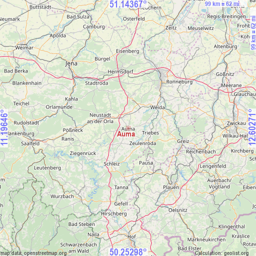
Auma GPS coordinates[2]
50° 42' 1.584" North, 11° 53' 58.488" East
| Map corner | latitude | longitude |
|---|---|---|
| Upper-left | 51.14367°, | 11.19646° |
| Center: | 50.70044°, | 11.89958° |
| Lower-right: | 50.25298°, | 12.60271° |
| Map W x H: | 99×99 km | = 61.5×61.5mi |
| max Lat: | 55.01917° ⇑47.8% North |
| Auma: | 50.70044° |
| min Lat: | ⇓52.2% South 47.40724° |
| min Long | Auma | max Long |
| 5.92978° | 11.89958° | 14.98853° |
| W 80.2%⇐ | ⇒19.8% E |
Elevation
Elevation of Auma is 395 m = 1296 ft, and this is 145.9 m = 479 ft above average elevation for this country.
| Max E: |
1256 m = 4121 ft | 25.3% |
| Auma | 395 m 1296 ft | |
| Avg. | 249.1 m = 817 ft | |
Min E: |
-5 m = -16 ft | 74.7% |
See also: Germany elevation on elevation.city.
Geographical zone
Auma is located in North temperate zone (between Tropic of Cancer and the Arctic Circle). Distance of this North polar circle is 1763.8 km =1096 mi to North.| Distance of | km | miles | from Auma |
|---|---|---|---|
| North Pole | 4369.7 | 2715.2 | to North |
| Arctic Circle | 1763.8 | 1096 | to North |
| Tropic Cancer | 3031.4 | 1883.6 | to South |
| Equator | 5637.4 | 3502.9 | to South |


Nearby cities:
15 places around Auma: (largest is in red/bold)
• Chursdorf
5.1 km =3.2 mi,  222°
222°
• Dreitzsch
7.9 km =4.9 mi,  297°
297°
• Geroda
7.4 km =4.6 mi,  0°
0°
• Göschitz
7.8 km =4.8 mi,  197°
197°
• Lemnitz
5.2 km =3.2 mi, 296°
• Miesitz
5.9 km =3.7 mi,  308°
308°
• Mittelpöllnitz
5.6 km =3.5 mi,  12°
12°
• Moßbach
6.1 km =3.8 mi,  251°
251°
• Reinsdorf
4.2 km =2.6 mi,  237°
237°
• Schmieritz
7.2 km =4.5 mi,  284°
284°
• Tegau
6.1 km =3.8 mi, 202°
• Triptis
4.4 km =2.7 mi,  332°
332°
• Tömmelsdorf
2.9 km =1.8 mi, 307°
• Weißendorf
7.3 km =4.5 mi,  105°
105°
• Zeulenroda
8 km =5 mi,  131°
131°
Sources, notices
• [Note1] Compared only with cities in Germany existing in our database
• [Src1] Map data: © OpenStreetMap contributors (CC-BY-SA)
• [Src2] Other city data from geonames.org with taken over terms of usage.
• [Src3] Geographical zone / Annual Mean Temperature by Robert A. Rohde @ Wikipedia
