Fröndenberg geodata
Fröndenberg (North Rhine-Westphalia) is a populated place; located in Germany in Europe/Berlin (GMT+2) time zone. With population of 22,964 people, there are 648 cities with bigger population in this country. Compared to other cities in Germany, 65.9% of cities are located further ↓South; 81.6% of cities are located further →East and 58.6% of cities have higher elevation than Fröndenberg. Note1
Administrative division(s):
- Level 1: North Rhine-Westphalia
- Level 2: Regierungsbezirk Arnsberg
- Level 3: Kreis Unna
- Level 4: Fröndenberg/Ruhr


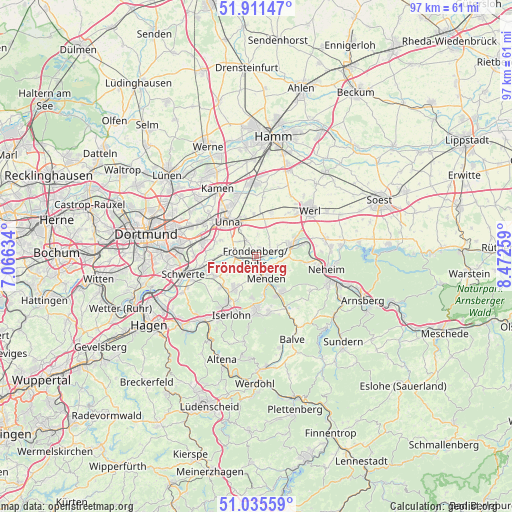
Fröndenberg GPS coordinates[2]
51° 28' 32.268" North, 7° 46' 10.056" East
| Map corner | latitude | longitude |
|---|---|---|
| Upper-left | 51.91147°, | 7.06634° |
| Center: | 51.47563°, | 7.76946° |
| Lower-right: | 51.03559°, | 8.47259° |
| Map W x H: | 97.4×97.4 km | = 60.5×60.5mi |
| max Lat: | 55.01917° ⇑34.1% North |
| Fröndenberg: | 51.47563° |
| min Lat: | ⇓65.9% South 47.40724° |
| min Long | Fröndenberg | max Long |
| 5.92978° | 7.76946° | 14.98853° |
| W 18.4%⇐ | ⇒81.6% E |
Elevation
Elevation of Fröndenberg is 163 m = 535 ft, and this is 86.1 m = 282 ft below average elevation for this country.
| Max E: |
1256 m = 4121 ft | 58.6% |
| Avg. | 249.1 m = 817 ft | |
| Fröndenberg | 163 m = 535 ft | |
Min E: |
-5 m = -16 ft | 41.4% |
See also: Germany elevation on elevation.city.
Geographical zone
Fröndenberg is located in North temperate zone (between Tropic of Cancer and the Arctic Circle). Distance of this North polar circle is 1677.6 km =1042.4 mi to North.| Distance of | km | miles | from Fröndenberg |
|---|---|---|---|
| North Pole | 4283.5 | 2661.6 | to North |
| Arctic Circle | 1677.6 | 1042.4 | to North |
| Tropic Cancer | 3117.6 | 1937.2 | to South |
| Equator | 5723.6 | 3556.5 | to South |


Nearby cities:
15 places around Fröndenberg: (largest is in red/bold)
• Balve
17.3 km =10.7 mi,  157°
157°
• Bergkamen
17.9 km =11.1 mi,  331°
331°
• Bönen
13.8 km =8.6 mi,  359°
359°
• Hemer
9.8 km =6.1 mi,  179°
179°
• Holzwickede
9.8 km =6.1 mi,  286°
286°
• Iserlohn
12.1 km =7.5 mi,  202°
202°
• Kamen
14.9 km =9.3 mi, 330°
• Lanstrop
17.8 km =11.1 mi,  308°
308°
• Menden
3.6 km =2.2 mi,  170°
170°
• Nachrodt-Wiblingwerde
20.6 km =12.8 mi,  210°
210°
• Schwerte
14.4 km =8.9 mi,  255°
255°
• Unna
8.9 km =5.5 mi,  321°
321°
• Welver
20.8 km =12.9 mi,  41°
41°
• Werl
13.3 km =8.3 mi,  48°
48°
• Wickede
7.1 km =4.4 mi,  70°
70°
In other languages:
- In German: Fröndenberg/Ruhr, Fröndenberg
- In Italian: Fröndenberg/Ruhr
- In Russian: Фрёнденберг-на-Руре
- In Chinese: 弗伦登贝格
Sources, notices
• [Note1] Compared only with cities in Germany existing in our database
• [Src1] Map data: © OpenStreetMap contributors (CC-BY-SA)
• [Src2] Other city data from geonames.org with taken over terms of usage.
• [Src3] Geographical zone / Annual Mean Temperature by Robert A. Rohde @ Wikipedia
