Kamen geodata
Kamen (North Rhine-Westphalia) is a populated place; located in Germany in Europe/Berlin (GMT+2) time zone. With population of 45,927 people, there are 256 cities with bigger population in this country. Compared to other cities in Germany, 67.5% of cities are located further ↓South; 83.7% of cities are located further →East and 74.5% of cities have higher elevation than Kamen. Note1
Administrative division(s):
- Level 1: North Rhine-Westphalia
- Level 2: Regierungsbezirk Arnsberg
- Level 3: Kreis Unna
- Level 4: Kamen


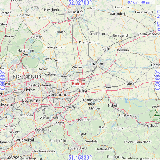
Kamen GPS coordinates[2]
51° 35' 32.316" North, 7° 39' 49.68" East
| Map corner | latitude | longitude |
|---|---|---|
| Upper-left | 52.02703°, | 6.96068° |
| Center: | 51.59231°, | 7.6638° |
| Lower-right: | 51.15339°, | 8.36693° |
| Map W x H: | 97.1×97.1 km | = 60.3×60.3mi |
| max Lat: | 55.01917° ⇑32.5% North |
| Kamen: | 51.59231° |
| min Lat: | ⇓67.5% South 47.40724° |
| min Long | Kamen | max Long |
| 5.92978° | 7.6638° | 14.98853° |
| W 16.3%⇐ | ⇒83.7% E |
Elevation
Elevation of Kamen is 65 m = 213 ft, and this is 184.1 m = 604 ft below average elevation for this country.
| Max E: |
1256 m = 4121 ft | 74.5% |
| Avg. | 249.1 m = 817 ft | |
| Kamen | 65 m = 213 ft | |
Min E: |
-5 m = -16 ft | 25.5% |
See also: Kamen elevation on elevation.city.
Geographical zone
Kamen is located in North temperate zone (between Tropic of Cancer and the Arctic Circle). Distance of this North polar circle is 1664.6 km =1034.3 mi to North.| Distance of | km | miles | from Kamen |
|---|---|---|---|
| North Pole | 4270.5 | 2653.6 | to North |
| Arctic Circle | 1664.6 | 1034.3 | to North |
| Tropic Cancer | 3130.6 | 1945.3 | to South |
| Equator | 5736.5 | 3564.5 | to South |


Nearby cities:
15 places around Kamen: (largest is in red/bold)
• Bergkamen
3 km =1.9 mi,  333°
333°
• Bönen
7.2 km =4.5 mi,  83°
83°
• Dortmund
16.2 km =10.1 mi,  237°
237°
• Fröndenberg
14.9 km =9.3 mi,  150°
150°
• Hamm
14.6 km =9.1 mi,  47°
47°
• Holzwickede
10.5 km =6.5 mi,  191°
191°
• Lanstrop
6.9 km =4.3 mi,  253°
253°
• Lünen
9.7 km =6 mi,  285°
285°
• Schwerte
17.8 km =11.1 mi,  201°
201°
• Selm
17.8 km =11.1 mi,  310°
310°
• Unna
6.3 km =3.9 mi,  163°
163°
• Waltrop
18.3 km =11.4 mi,  280°
280°
• Werl
17.8 km =11.1 mi,  103°
103°
• Werne
8.3 km =5.2 mi,  345°
345°
• Wickede
17.6 km =10.9 mi,  127°
127°
Sources, notices
• [Note1] Compared only with cities in Germany existing in our database
• [Src1] Map data: © OpenStreetMap contributors (CC-BY-SA)
• [Src2] Other city data from geonames.org with taken over terms of usage.
• [Src3] Geographical zone / Annual Mean Temperature by Robert A. Rohde @ Wikipedia
