Bönen geodata
Bönen (North Rhine-Westphalia) is a seat of a fourth-order administrative division; located in Germany in Europe/Berlin (GMT+2) time zone. With population of 19,393 people, there are 801 cities with bigger population in this country. Compared to other cities in Germany, 67.6% of cities are located further ↓South; 81.8% of cities are located further →East and 72.8% of cities have higher elevation than Bönen. Note1
Administrative division(s):
- Level 1: North Rhine-Westphalia
- Level 2: Regierungsbezirk Arnsberg
- Level 3: Kreis Unna
- Level 4: Bönen


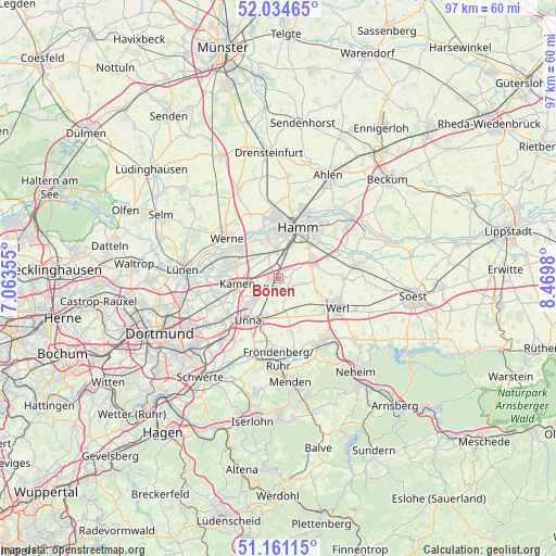
Bönen GPS coordinates[2]
51° 36' 0" North, 7° 46' 0.012" East
| Map corner | latitude | longitude |
|---|---|---|
| Upper-left | 52.03465°, | 7.06355° |
| Center: | 51.6°, | 7.76667° |
| Lower-right: | 51.16115°, | 8.4698° |
| Map W x H: | 97.1×97.1 km | = 60.3×60.3mi |
| max Lat: | 55.01917° ⇑32.4% North |
| Bönen: | 51.6° |
| min Lat: | ⇓67.6% South 47.40724° |
| min Long | Bönen | max Long |
| 5.92978° | 7.76667° | 14.98853° |
| W 18.2%⇐ | ⇒81.8% E |
Elevation
Elevation of Bönen is 73 m = 240 ft, and this is 176.1 m = 578 ft below average elevation for this country.
| Max E: |
1256 m = 4121 ft | 72.8% |
| Avg. | 249.1 m = 817 ft | |
| Bönen | 73 m = 240 ft | |
Min E: |
-5 m = -16 ft | 27.2% |
See also: Germany elevation on elevation.city.
Geographical zone
Bönen is located in North temperate zone (between Tropic of Cancer and the Arctic Circle). Distance of this North polar circle is 1663.8 km =1033.8 mi to North.| Distance of | km | miles | from Bönen |
|---|---|---|---|
| North Pole | 4269.7 | 2653.1 | to North |
| Arctic Circle | 1663.8 | 1033.8 | to North |
| Tropic Cancer | 3131.5 | 1945.8 | to South |
| Equator | 5737.4 | 3565.1 | to South |


Nearby cities:
15 places around Bönen: (largest is in red/bold)
• Ahlen
20 km =12.4 mi,  24°
24°
• Bergkamen
8.6 km =5.3 mi,  282°
282°
• Drensteinfurt
21.8 km =13.5 mi,  354°
354°
• Fröndenberg
13.8 km =8.6 mi,  179°
179°
• Hamm
9.7 km =6 mi, 22°
• Holzwickede
14.4 km =8.9 mi,  219°
219°
• Kamen
7.2 km =4.5 mi,  263°
263°
• Lanstrop
14 km =8.7 mi, 258°
• Lünen
16.5 km =10.3 mi, 276°
• Menden
17.4 km =10.8 mi, 177°
• Unna
8.7 km =5.4 mi, 217°
• Welver
13.9 km =8.6 mi,  82°
82°
• Werl
11.3 km =7 mi,  116°
116°
• Werne
11.6 km =7.2 mi,  308°
308°
• Wickede
13.4 km =8.3 mi,  149°
149°
Sources, notices
• [Note1] Compared only with cities in Germany existing in our database
• [Src1] Map data: © OpenStreetMap contributors (CC-BY-SA)
• [Src2] Other city data from geonames.org with taken over terms of usage.
• [Src3] Geographical zone / Annual Mean Temperature by Robert A. Rohde @ Wikipedia
