Lanstrop geodata
Lanstrop (North Rhine-Westphalia) is a populated place; located in Germany in Europe/Berlin (GMT+2) time zone. With population of 4,176 people, there are 3186 cities with bigger population in this country. Compared to other cities in Germany, 67.2% of cities are located further ↓South; 85.5% of cities are located further →East and 72.4% of cities have higher elevation than Lanstrop. Note1
Administrative division(s):
- Level 1: North Rhine-Westphalia
- Level 2: Regierungsbezirk Arnsberg
- Level 3: Kreisfreie Stadt Dortmund
- Level 4: Dortmund


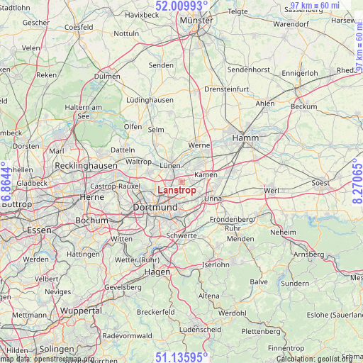
Lanstrop GPS coordinates[2]
51° 34' 30.144" North, 7° 34' 3.072" East
| Map corner | latitude | longitude |
|---|---|---|
| Upper-left | 52.00993°, | 6.8644° |
| Center: | 51.57504°, | 7.56752° |
| Lower-right: | 51.13595°, | 8.27065° |
| Map W x H: | 97.2×97.2 km | = 60.4×60.4mi |
| max Lat: | 55.01917° ⇑32.8% North |
| Lanstrop: | 51.57504° |
| min Lat: | ⇓67.2% South 47.40724° |
| min Long | Lanstrop | max Long |
| 5.92978° | 7.56752° | 14.98853° |
| W 14.5%⇐ | ⇒85.5% E |
Elevation
Elevation of Lanstrop is 75 m = 246 ft, and this is 174.1 m = 571 ft below average elevation for this country.
| Max E: |
1256 m = 4121 ft | 72.4% |
| Avg. | 249.1 m = 817 ft | |
| Lanstrop | 75 m = 246 ft | |
Min E: |
-5 m = -16 ft | 27.6% |
See also: Germany elevation on elevation.city.
Geographical zone
Lanstrop is located in North temperate zone (between Tropic of Cancer and the Arctic Circle). Distance of this North polar circle is 1666.6 km =1035.6 mi to North.| Distance of | km | miles | from Lanstrop |
|---|---|---|---|
| North Pole | 4272.5 | 2654.8 | to North |
| Arctic Circle | 1666.6 | 1035.6 | to North |
| Tropic Cancer | 3128.7 | 1944.1 | to South |
| Equator | 5734.6 | 3563.3 | to South |


Nearby cities:
15 places around Lanstrop: (largest is in red/bold)
• Bergkamen
7 km =4.3 mi,  49°
49°
• Bönen
14 km =8.7 mi,  78°
78°
• Castrop-Rauxel
17.8 km =11.1 mi,  263°
263°
• Datteln
17.8 km =11.1 mi,  300°
300°
• Dortmund
9.7 km =6 mi,  226°
226°
• Fröndenberg
17.8 km =11.1 mi,  128°
128°
• Holzwickede
9.5 km =5.9 mi,  151°
151°
• Kamen
6.9 km =4.3 mi,  73°
73°
• Lünen
5.3 km =3.3 mi,  329°
329°
• Nordkirchen
18.4 km =11.4 mi,  350°
350°
• Schwerte
14.6 km =9.1 mi,  180°
180°
• Selm
15.2 km =9.4 mi, 333°
• Unna
9.4 km =5.8 mi,  116°
116°
• Waltrop
12.5 km =7.8 mi,  294°
294°
• Werne
11 km =6.8 mi,  24°
24°
Sources, notices
• [Note1] Compared only with cities in Germany existing in our database
• [Src1] Map data: © OpenStreetMap contributors (CC-BY-SA)
• [Src2] Other city data from geonames.org with taken over terms of usage.
• [Src3] Geographical zone / Annual Mean Temperature by Robert A. Rohde @ Wikipedia
