Friemar geodata
Friemar (Thuringia) is a seat of a fourth-order administrative division; located in Germany in Europe/Berlin (GMT+2) time zone. With population of 1,213 people, there are 6527 cities with bigger population in this country. Compared to other cities in Germany, 57.7% of cities are located further ↓South; 63.9% of cities are located further ←West and 59.5% of cities have lower elevation than Friemar. Note1


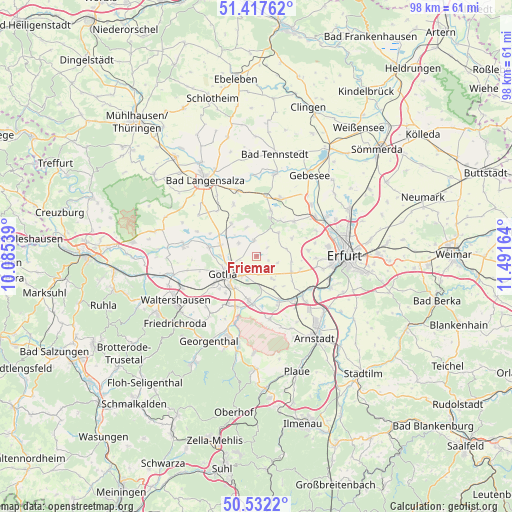
Friemar GPS coordinates[2]
50° 58' 37.272" North, 10° 47' 18.636" East
| Map corner | latitude | longitude |
|---|---|---|
| Upper-left | 51.41762°, | 10.08539° |
| Center: | 50.97702°, | 10.78851° |
| Lower-right: | 50.5322°, | 11.49164° |
| Map W x H: | 98.4×98.4 km | = 61.1×61.1mi |
| max Lat: | 55.01917° ⇑42.3% North |
| Friemar: | 50.97702° |
| min Lat: | ⇓57.7% South 47.40724° |
| min Long | Friemar | max Long |
| 5.92978° | 10.78851° | 14.98853° |
| W 63.9%⇐ | ⇒36.1% E |
Elevation
Elevation of Friemar is 287 m = 942 ft, and this is 37.9 m = 124 ft above average elevation for this country.
| Max E: |
1256 m = 4121 ft | 40.5% |
| Friemar | 287 m 942 ft | |
| Avg. | 249.1 m = 817 ft | |
Min E: |
-5 m = -16 ft | 59.5% |
See also: Germany elevation on elevation.city.
Geographical zone
Friemar is located in North temperate zone (between Tropic of Cancer and the Arctic Circle). Distance of this North polar circle is 1733.1 km =1076.9 mi to North.| Distance of | km | miles | from Friemar |
|---|---|---|---|
| North Pole | 4338.9 | 2696.1 | to North |
| Arctic Circle | 1733.1 | 1076.9 | to North |
| Tropic Cancer | 3062.2 | 1902.8 | to South |
| Equator | 5668.1 | 3522 | to South |


Nearby cities:
15 places around Friemar: (largest is in red/bold)
• Bienstädt
6.2 km =3.9 mi,  44°
44°
• Bufleben
4.6 km =2.9 mi,  303°
303°
• Eschenbergen
5.9 km =3.7 mi,  339°
339°
• Gamstädt
7.4 km =4.6 mi,  114°
114°
• Gierstädt
7.7 km =4.8 mi,  19°
19°
• Gotha
6.9 km =4.3 mi,  242°
242°
• Grabsleben
5.6 km =3.5 mi,  144°
144°
• Molschleben
2.6 km =1.6 mi,  351°
351°
• Nottleben
4.5 km =2.8 mi,  104°
104°
• Pferdingsleben
2.3 km =1.4 mi,  120°
120°
• Remstädt
7.1 km =4.4 mi,  271°
271°
• Seebergen
6.3 km =3.9 mi,  173°
173°
• Tröchtelborn
3.2 km =2 mi, 37°
• Tüttleben
3.5 km =2.2 mi,  180°
180°
• Zimmernsupra
5.5 km =3.4 mi,  82°
82°
Sources, notices
• [Note1] Compared only with cities in Germany existing in our database
• [Src1] Map data: © OpenStreetMap contributors (CC-BY-SA)
• [Src2] Other city data from geonames.org with taken over terms of usage.
• [Src3] Geographical zone / Annual Mean Temperature by Robert A. Rohde @ Wikipedia
