Remstädt geodata
Remstädt (Thuringia) is a seat of a fourth-order administrative division; located in Germany in Europe/Berlin (GMT+2) time zone. With population of 998 people, there are 7194 cities with bigger population in this country. Compared to other cities in Germany, 57.8% of cities are located further ↓South; 62.3% of cities are located further ←West and 57.9% of cities have lower elevation than Remstädt. Note1


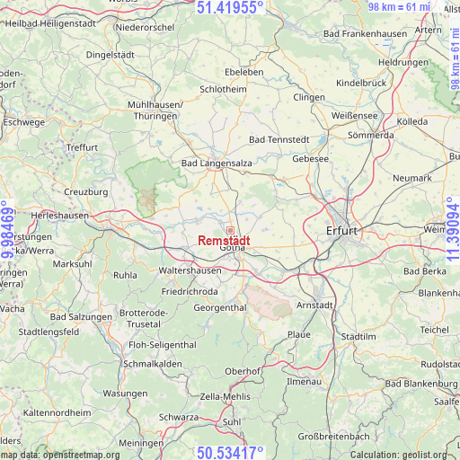
Remstädt GPS coordinates[2]
50° 58' 44.292" North, 10° 41' 16.116" East
| Map corner | latitude | longitude |
|---|---|---|
| Upper-left | 51.41955°, | 9.98469° |
| Center: | 50.97897°, | 10.68781° |
| Lower-right: | 50.53417°, | 11.39094° |
| Map W x H: | 98.4×98.4 km | = 61.1×61.1mi |
| max Lat: | 55.01917° ⇑42.2% North |
| Remstädt: | 50.97897° |
| min Lat: | ⇓57.8% South 47.40724° |
| min Long | Remstädt | max Long |
| 5.92978° | 10.68781° | 14.98853° |
| W 62.3%⇐ | ⇒37.7% E |
Elevation
Elevation of Remstädt is 278 m = 912 ft, and this is 28.9 m = 95 ft above average elevation for this country.
| Max E: |
1256 m = 4121 ft | 42.1% |
| Remstädt | 278 m 912 ft | |
| Avg. | 249.1 m = 817 ft | |
Min E: |
-5 m = -16 ft | 57.9% |
See also: Germany elevation on elevation.city.
Geographical zone
Remstädt is located in North temperate zone (between Tropic of Cancer and the Arctic Circle). Distance of this North polar circle is 1732.8 km =1076.7 mi to North.| Distance of | km | miles | from Remstädt |
|---|---|---|---|
| North Pole | 4338.7 | 2695.9 | to North |
| Arctic Circle | 1732.8 | 1076.7 | to North |
| Tropic Cancer | 3062.4 | 1902.9 | to South |
| Equator | 5668.3 | 3522.1 | to South |


Nearby cities:
15 places around Remstädt: (largest is in red/bold)
• Ballstädt
6.4 km =4 mi,  18°
18°
• Brüheim
7.7 km =4.8 mi,  287°
287°
• Bufleben
4 km =2.5 mi,  53°
53°
• Eschenbergen
7.3 km =4.5 mi,  43°
43°
• Friemar
7.1 km =4.4 mi,  91°
91°
• Goldbach
2.6 km =1.6 mi,  305°
305°
• Gotha
3.6 km =2.2 mi,  163°
163°
• Hochheim
4.4 km =2.7 mi,  340°
340°
• Molschleben
7.1 km =4.4 mi,  70°
70°
• Pferdingsleben
9.1 km =5.7 mi,  98°
98°
• Sonneborn
6.9 km =4.3 mi,  282°
282°
• Tüttleben
7.9 km =4.9 mi,  117°
117°
• Wangenheim
6.4 km =4 mi,  315°
315°
• Warza
2.4 km =1.5 mi,  352°
352°
• Westhausen
4.2 km =2.6 mi,  355°
355°
Sources, notices
• [Note1] Compared only with cities in Germany existing in our database
• [Src1] Map data: © OpenStreetMap contributors (CC-BY-SA)
• [Src2] Other city data from geonames.org with taken over terms of usage.
• [Src3] Geographical zone / Annual Mean Temperature by Robert A. Rohde @ Wikipedia
