Fladungen geodata
Fladungen (Bavaria) is a populated place; located in Germany in Europe/Berlin (GMT+2) time zone. With population of 2,337 people, there are 4619 cities with bigger population in this country. Compared to other cities in Germany, 52.3% of cities are located further ↑North; 52.4% of cities are located further ←West and 77.2% of cities have lower elevation than Fladungen. Note1
Administrative division(s):
- Level 1: Bavaria
- Level 2: Regierungsbezirk Unterfranken
- Level 3: Landkreis Rhön-Grabfeld
- Level 4: Fladungen


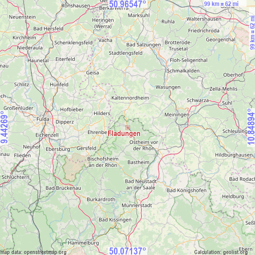
Fladungen GPS coordinates[2]
50° 31' 13.944" North, 10° 8' 44.916" East
| Map corner | latitude | longitude |
|---|---|---|
| Upper-left | 50.96547°, | 9.44269° |
| Center: | 50.52054°, | 10.14581° |
| Lower-right: | 50.07137°, | 10.84894° |
| Map W x H: | 99.4×99.4 km | = 61.8×61.8mi |
| max Lat: | 55.01917° ⇑52.3% North |
| Fladungen: | 50.52054° |
| min Lat: | ⇓47.7% South 47.40724° |
| min Long | Fladungen | max Long |
| 5.92978° | 10.14581° | 14.98853° |
| W 52.4%⇐ | ⇒47.6% E |
Elevation
Elevation of Fladungen is 414 m = 1358 ft, and this is 164.9 m = 541 ft above average elevation for this country.
| Max E: |
1256 m = 4121 ft | 22.8% |
| Fladungen | 414 m 1358 ft | |
| Avg. | 249.1 m = 817 ft | |
Min E: |
-5 m = -16 ft | 77.2% |
See also: Germany elevation on elevation.city.
Geographical zone
Fladungen is located in North temperate zone (between Tropic of Cancer and the Arctic Circle). Distance of this North polar circle is 1783.8 km =1108.4 mi to North.| Distance of | km | miles | from Fladungen |
|---|---|---|---|
| North Pole | 4389.7 | 2727.6 | to North |
| Arctic Circle | 1783.8 | 1108.4 | to North |
| Tropic Cancer | 3011.4 | 1871.2 | to South |
| Equator | 5617.4 | 3490.5 | to South |


Nearby cities:
15 places around Fladungen: (largest is in red/bold)
• Aschenhausen
9.6 km =6 mi,  23°
23°
• Birx
6.9 km =4.3 mi,  281°
281°
• Erbenhausen
5.1 km =3.2 mi,  3°
3°
• Frankenheim
6.1 km =3.8 mi,  295°
295°
• Hausen
2.1 km =1.3 mi,  220°
220°
• Kaltensundheim
9.6 km =6 mi, 4°
• Kaltenwestheim
10.1 km =6.3 mi,  348°
348°
• Melpers
3.3 km =2.1 mi,  5°
5°
• Oberelsbach
9.1 km =5.7 mi,  193°
193°
• Oberkatz
10.8 km =6.7 mi,  34°
34°
• Oberweid
9.7 km =6 mi,  323°
323°
• Ostheim vor der Rhön
9 km =5.6 mi,  138°
138°
• Sondheim vor der Rhön
6.2 km =3.9 mi,  172°
172°
• Stockheim
11.3 km =7 mi,  126°
126°
• Willmars
7.7 km =4.8 mi,  107°
107°
Sources, notices
• [Note1] Compared only with cities in Germany existing in our database
• [Src1] Map data: © OpenStreetMap contributors (CC-BY-SA)
• [Src2] Other city data from geonames.org with taken over terms of usage.
• [Src3] Geographical zone / Annual Mean Temperature by Robert A. Rohde @ Wikipedia
