Stockheim geodata
Stockheim (Bavaria) is a seat of a fourth-order administrative division; located in Germany in Europe/Berlin (GMT+2) time zone. With population of 1,142 people, there are 6727 cities with bigger population in this country. Compared to other cities in Germany, 53.6% of cities are located further ↑North; 54.8% of cities are located further ←West and 61.5% of cities have lower elevation than Stockheim. Note1
Administrative division(s):
- Level 1: Bavaria
- Level 2: Regierungsbezirk Unterfranken
- Level 3: Landkreis Rhön-Grabfeld
- Level 4: Stockheim


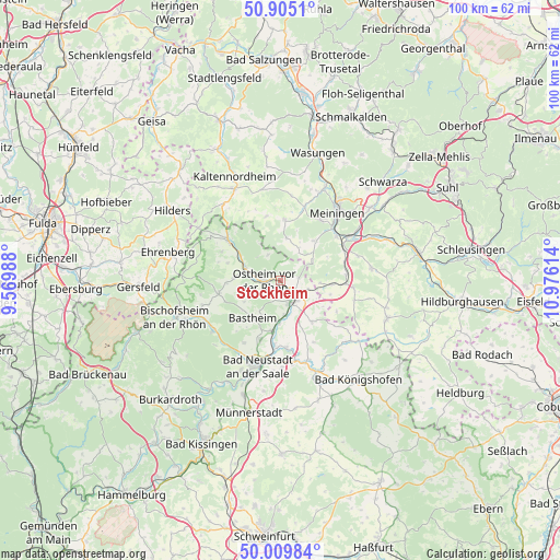
Stockheim GPS coordinates[2]
50° 27' 34.524" North, 10° 16' 22.836" East
| Map corner | latitude | longitude |
|---|---|---|
| Upper-left | 50.9051°, | 9.56988° |
| Center: | 50.45959°, | 10.27301° |
| Lower-right: | 50.00984°, | 10.97614° |
| Map W x H: | 99.5×99.5 km | = 61.8×61.8mi |
| max Lat: | 55.01917° ⇑53.6% North |
| Stockheim: | 50.45959° |
| min Lat: | ⇓46.4% South 47.40724° |
| min Long | Stockheim | max Long |
| 5.92978° | 10.27301° | 14.98853° |
| W 54.8%⇐ | ⇒45.2% E |
Elevation
Elevation of Stockheim is 299 m = 981 ft, and this is 49.9 m = 164 ft above average elevation for this country.
| Max E: |
1256 m = 4121 ft | 38.5% |
| Stockheim | 299 m 981 ft | |
| Avg. | 249.1 m = 817 ft | |
Min E: |
-5 m = -16 ft | 61.5% |
See also: Germany elevation on elevation.city.
Geographical zone
Stockheim is located in North temperate zone (between Tropic of Cancer and the Arctic Circle). Distance of this North polar circle is 1790.6 km =1112.6 mi to North.| Distance of | km | miles | from Stockheim |
|---|---|---|---|
| North Pole | 4396.5 | 2731.9 | to North |
| Arctic Circle | 1790.6 | 1112.6 | to North |
| Tropic Cancer | 3004.7 | 1867 | to South |
| Equator | 5610.6 | 3486.3 | to South |


Nearby cities:
15 places around Stockheim: (largest is in red/bold)
• Bastheim
8.2 km =5.1 mi,  216°
216°
• Behrungen
11.4 km =7.1 mi,  118°
118°
• Fladungen
11.3 km =7 mi,  306°
306°
• Hendungen
9.1 km =5.7 mi,  142°
142°
• Henneberg
6.9 km =4.3 mi,  57°
57°
• Mellrichstadt
4.1 km =2.5 mi,  148°
148°
• Oberelsbach
11.2 km =7 mi,  259°
259°
• Oberstreu
6.3 km =3.9 mi,  170°
170°
• Ostheim vor der Rhön
3 km =1.9 mi,  270°
270°
• Sondheim vor der Rhön
8.3 km =5.2 mi, 274°
• Sülzfeld
9.4 km =5.8 mi,  41°
41°
• Unsleben
9 km =5.6 mi,  189°
189°
• Willmars
4.8 km =3 mi,  340°
340°
• Wollbach
10.7 km =6.6 mi,  195°
195°
• Wölfershausen
11.6 km =7.2 mi,  76°
76°
Sources, notices
• [Note1] Compared only with cities in Germany existing in our database
• [Src1] Map data: © OpenStreetMap contributors (CC-BY-SA)
• [Src2] Other city data from geonames.org with taken over terms of usage.
• [Src3] Geographical zone / Annual Mean Temperature by Robert A. Rohde @ Wikipedia
