Eurasburg geodata
Eurasburg (Bavaria) is a seat of a fourth-order administrative division; located in Germany in Europe/Berlin (GMT+2) time zone. With population of 1,657 people, there are 5593 cities with bigger population in this country. Compared to other cities in Germany, 90.9% of cities are located further ↑North; 68.1% of cities are located further ←West and 87.7% of cities have lower elevation than Eurasburg. Note1
Administrative division(s):
- Level 1: Bavaria
- Level 2: Swabia
- Level 3: Landkreis Aichach-Friedberg
- Level 4: Eurasburg


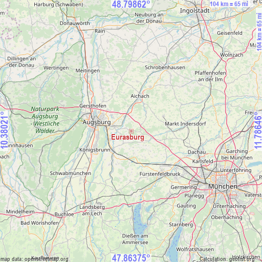
Eurasburg GPS coordinates[2]
48° 19' 59.988" North, 11° 4' 59.988" East
| Map corner | latitude | longitude |
|---|---|---|
| Upper-left | 48.79862°, | 10.38021° |
| Center: | 48.33333°, | 11.08333° |
| Lower-right: | 47.86375°, | 11.78646° |
| Map W x H: | 103.9×103.9 km | = 64.6×64.6mi |
| max Lat: | 55.01917° ⇑90.9% North |
| Eurasburg: | 48.33333° |
| min Lat: | ⇓9.1% South 47.40724° |
| min Long | Eurasburg | max Long |
| 5.92978° | 11.08333° | 14.98853° |
| W 68.1%⇐ | ⇒31.9% E |
Elevation
Elevation of Eurasburg is 491 m = 1611 ft, and this is 241.9 m = 794 ft above average elevation for this country.
| Max E: |
1256 m = 4121 ft | 12.3% |
| Eurasburg | 491 m 1611 ft | |
| Avg. | 249.1 m = 817 ft | |
Min E: |
-5 m = -16 ft | 87.7% |
See also: Germany elevation on elevation.city.
Geographical zone
Eurasburg is located in North temperate zone (between Tropic of Cancer and the Arctic Circle). Distance of this North polar circle is 2027 km =1259.5 mi to North.| Distance of | km | miles | from Eurasburg |
|---|---|---|---|
| North Pole | 4632.9 | 2878.7 | to North |
| Arctic Circle | 2027 | 1259.5 | to North |
| Tropic Cancer | 2768.2 | 1720.1 | to South |
| Equator | 5374.2 | 3339.4 | to South |


Nearby cities:
15 places around Eurasburg: (largest is in red/bold)
• Adelzhausen
4.8 km =3 mi,  57°
57°
• Althegnenberg
11.2 km =7 mi,  186°
186°
• Dasing
6.3 km =3.9 mi,  334°
334°
• Egenhofen
8.3 km =5.2 mi,  132°
132°
• Friedberg
7.8 km =4.8 mi,  289°
289°
• Kissing
8.9 km =5.5 mi,  248°
248°
• Merching
12.1 km =7.5 mi,  216°
216°
• Mering
10.5 km =6.5 mi, 224°
• Mittelstetten
9.3 km =5.8 mi,  172°
172°
• Obergriesbach
10 km =6.2 mi,  353°
353°
• Oberschweinbach
11.9 km =7.4 mi,  153°
153°
• Odelzhausen
9 km =5.6 mi,  107°
107°
• Pfaffenhofen
11.2 km =7 mi,  53°
53°
• Ried
5.6 km =3.5 mi,  211°
211°
• Sielenbach
9.6 km =6 mi,  39°
39°
Sources, notices
• [Note1] Compared only with cities in Germany existing in our database
• [Src1] Map data: © OpenStreetMap contributors (CC-BY-SA)
• [Src2] Other city data from geonames.org with taken over terms of usage.
• [Src3] Geographical zone / Annual Mean Temperature by Robert A. Rohde @ Wikipedia
