Obergriesbach geodata
Obergriesbach (Bavaria) is a seat of a fourth-order administrative division; located in Germany in Europe/Berlin (GMT+2) time zone. With population of 2,050 people, there are 4996 cities with bigger population in this country. Compared to other cities in Germany, 90% of cities are located further ↑North; 67.9% of cities are located further ←West and 86.4% of cities have lower elevation than Obergriesbach. Note1
Administrative division(s):
- Level 1: Bavaria
- Level 2: Swabia
- Level 3: Landkreis Aichach-Friedberg
- Level 4: Obergriesbach


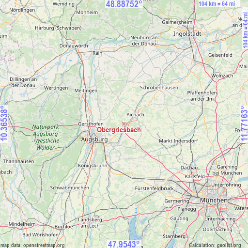
Obergriesbach GPS coordinates[2]
48° 25' 22.98" North, 11° 4' 6.6" East
| Map corner | latitude | longitude |
|---|---|---|
| Upper-left | 48.88752°, | 10.36538° |
| Center: | 48.42305°, | 11.0685° |
| Lower-right: | 47.9543°, | 11.77163° |
| Map W x H: | 103.8×103.8 km | = 64.5×64.5mi |
| max Lat: | 55.01917° ⇑90% North |
| Obergriesbach: | 48.42305° |
| min Lat: | ⇓10% South 47.40724° |
| min Long | Obergriesbach | max Long |
| 5.92978° | 11.0685° | 14.98853° |
| W 67.9%⇐ | ⇒32.1% E |
Elevation
Elevation of Obergriesbach is 481 m = 1578 ft, and this is 231.9 m = 761 ft above average elevation for this country.
| Max E: |
1256 m = 4121 ft | 13.6% |
| Obergriesbach | 481 m 1578 ft | |
| Avg. | 249.1 m = 817 ft | |
Min E: |
-5 m = -16 ft | 86.4% |
See also: Germany elevation on elevation.city.
Geographical zone
Obergriesbach is located in North temperate zone (between Tropic of Cancer and the Arctic Circle). Distance of this North polar circle is 2017 km =1253.3 mi to North.| Distance of | km | miles | from Obergriesbach |
|---|---|---|---|
| North Pole | 4622.9 | 2872.5 | to North |
| Arctic Circle | 2017 | 1253.3 | to North |
| Tropic Cancer | 2778.2 | 1726.3 | to South |
| Equator | 5384.1 | 3345.5 | to South |


Nearby cities:
15 places around Obergriesbach: (largest is in red/bold)
• Adelzhausen
9 km =5.6 mi,  144°
144°
• Affing
7.9 km =4.9 mi,  307°
307°
• Aichach
6.2 km =3.9 mi,  51°
51°
• Aindling
13.2 km =8.2 mi,  319°
319°
• Augsburg
13.8 km =8.6 mi,  245°
245°
• Dasing
4.5 km =2.8 mi,  200°
200°
• Eurasburg
10 km =6.2 mi,  173°
173°
• Friedberg
9.6 km =6 mi,  220°
220°
• Hollenbach
6.7 km =4.2 mi,  358°
358°
• Inchenhofen
10.6 km =6.6 mi,  18°
18°
• Kühbach
11.5 km =7.1 mi, 49°
• Petersdorf
10.7 km =6.6 mi,  346°
346°
• Pfaffenhofen
10.6 km =6.6 mi,  108°
108°
• Rehling
12 km =7.5 mi,  303°
303°
• Sielenbach
7.7 km =4.8 mi, 109°
Sources, notices
• [Note1] Compared only with cities in Germany existing in our database
• [Src1] Map data: © OpenStreetMap contributors (CC-BY-SA)
• [Src2] Other city data from geonames.org with taken over terms of usage.
• [Src3] Geographical zone / Annual Mean Temperature by Robert A. Rohde @ Wikipedia
