Pfaffenhofen geodata
Pfaffenhofen (Bavaria) is a populated place; located in Germany in Europe/Berlin (GMT+2) time zone. With population of 1,717 people, there are 5483 cities with bigger population in this country. Compared to other cities in Germany, 90.3% of cities are located further ↑North; 70.1% of cities are located further ←West and 91.4% of cities have lower elevation than Pfaffenhofen. Note1
Administrative division(s):
- Level 1: Bavaria
- Level 2: Upper Bavaria
- Level 3: Landkreis Dachau
- Level 4: Altomünster, Markt


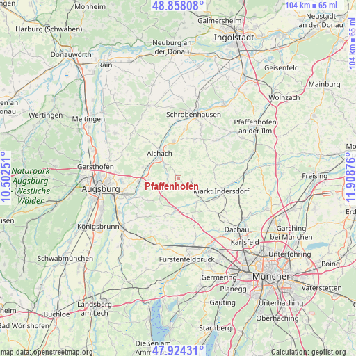
Pfaffenhofen GPS coordinates[2]
48° 23' 36.024" North, 11° 12' 20.268" East
| Map corner | latitude | longitude |
|---|---|---|
| Upper-left | 48.85808°, | 10.50251° |
| Center: | 48.39334°, | 11.20563° |
| Lower-right: | 47.92431°, | 11.90876° |
| Map W x H: | 103.8×103.8 km | = 64.5×64.5mi |
| max Lat: | 55.01917° ⇑90.3% North |
| Pfaffenhofen: | 48.39334° |
| min Lat: | ⇓9.7% South 47.40724° |
| min Long | Pfaffenhofen | max Long |
| 5.92978° | 11.20563° | 14.98853° |
| W 70.1%⇐ | ⇒29.9% E |
Elevation
Elevation of Pfaffenhofen is 534 m = 1752 ft, and this is 284.9 m = 935 ft above average elevation for this country.
| Max E: |
1256 m = 4121 ft | 8.6% |
| Pfaffenhofen | 534 m 1752 ft | |
| Avg. | 249.1 m = 817 ft | |
Min E: |
-5 m = -16 ft | 91.4% |
See also: Germany elevation on elevation.city.
Geographical zone
Pfaffenhofen is located in North temperate zone (between Tropic of Cancer and the Arctic Circle). Distance of this North polar circle is 2020.3 km =1255.4 mi to North.| Distance of | km | miles | from Pfaffenhofen |
|---|---|---|---|
| North Pole | 4626.2 | 2874.6 | to North |
| Arctic Circle | 2020.3 | 1255.4 | to North |
| Tropic Cancer | 2774.9 | 1724.2 | to South |
| Equator | 5380.8 | 3343.5 | to South |


Nearby cities:
15 places around Pfaffenhofen: (largest is in red/bold)
• Adelzhausen
6.4 km =4 mi,  230°
230°
• Aichach
8.9 km =5.5 mi,  323°
323°
• Altomünster
3.8 km =2.4 mi,  99°
99°
• Dasing
11.8 km =7.3 mi,  265°
265°
• Erdweg
9.9 km =6.2 mi,  133°
133°
• Eurasburg
11.2 km =7 mi, 233°
• Gachenbach
12 km =7.5 mi,  9°
9°
• Hilgertshausen-Tandern
11.7 km =7.3 mi,  69°
69°
• Kühbach
10.9 km =6.8 mi,  352°
352°
• Obergriesbach
10.6 km =6.6 mi,  288°
288°
• Odelzhausen
9.4 km =5.8 mi,  183°
183°
• Ried
10.1 km =6.3 mi,  23°
23°
• Schiltberg
8.4 km =5.2 mi, 22°
• Schwabhausen
11.2 km =7 mi,  85°
85°
• Sielenbach
3 km =1.9 mi,  284°
284°
Sources, notices
• [Note1] Compared only with cities in Germany existing in our database
• [Src1] Map data: © OpenStreetMap contributors (CC-BY-SA)
• [Src2] Other city data from geonames.org with taken over terms of usage.
• [Src3] Geographical zone / Annual Mean Temperature by Robert A. Rohde @ Wikipedia
