Egenhofen geodata
Egenhofen (Bavaria) is a seat of a fourth-order administrative division; located in Germany in Europe/Berlin (GMT+2) time zone. With population of 3,252 people, there are 3787 cities with bigger population in this country. Compared to other cities in Germany, 91.5% of cities are located further ↑North; 69.4% of cities are located further ←West and 89.6% of cities have lower elevation than Egenhofen. Note1
Administrative division(s):
- Level 1: Bavaria
- Level 2: Upper Bavaria
- Level 3: Landkreis Fürstenfeldbruck
- Level 4: Egenhofen


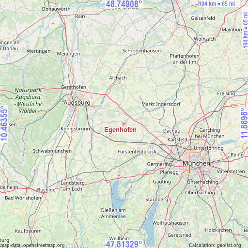
Egenhofen GPS coordinates[2]
48° 16' 59.988" North, 11° 10' 0.012" East
| Map corner | latitude | longitude |
|---|---|---|
| Upper-left | 48.74908°, | 10.46355° |
| Center: | 48.28333°, | 11.16667° |
| Lower-right: | 47.81329°, | 11.8698° |
| Map W x H: | 104.1×10⁴ km | = 64.7×64.6mi |
| max Lat: | 55.01917° ⇑91.5% North |
| Egenhofen: | 48.28333° |
| min Lat: | ⇓8.5% South 47.40724° |
| min Long | Egenhofen | max Long |
| 5.92978° | 11.16667° | 14.98853° |
| W 69.4%⇐ | ⇒30.6% E |
Elevation
Elevation of Egenhofen is 509 m = 1670 ft, and this is 259.9 m = 853 ft above average elevation for this country.
| Max E: |
1256 m = 4121 ft | 10.4% |
| Egenhofen | 509 m 1670 ft | |
| Avg. | 249.1 m = 817 ft | |
Min E: |
-5 m = -16 ft | 89.6% |
See also: Germany elevation on elevation.city.
Geographical zone
Egenhofen is located in North temperate zone (between Tropic of Cancer and the Arctic Circle). Distance of this North polar circle is 2032.6 km =1263 mi to North.| Distance of | km | miles | from Egenhofen |
|---|---|---|---|
| North Pole | 4638.5 | 2882.2 | to North |
| Arctic Circle | 2032.6 | 1263 | to North |
| Tropic Cancer | 2762.7 | 1716.7 | to South |
| Equator | 5368.6 | 3335.9 | to South |


Nearby cities:
15 places around Egenhofen: (largest is in red/bold)
• Adelshofen
11.7 km =7.3 mi,  198°
198°
• Adelzhausen
8.4 km =5.2 mi,  345°
345°
• Althegnenberg
9.3 km =5.8 mi,  233°
233°
• Erdweg
11.5 km =7.1 mi,  61°
61°
• Eurasburg
8.3 km =5.2 mi,  312°
312°
• Hattenhofen
7.8 km =4.8 mi,  209°
209°
• Maisach
10.5 km =6.5 mi,  135°
135°
• Mammendorf
8.3 km =5.2 mi,  181°
181°
• Mittelstetten
6.2 km =3.9 mi, 233°
• Oberschweinbach
5.1 km =3.2 mi,  189°
189°
• Odelzhausen
3.7 km =2.3 mi,  39°
39°
• Pfaffenhofen
12.6 km =7.8 mi,  13°
13°
• Ried
9.1 km =5.7 mi,  274°
274°
• Sielenbach
13 km =8.1 mi,  0°
0°
• Sulzemoos
7.2 km =4.5 mi,  83°
83°
Sources, notices
• [Note1] Compared only with cities in Germany existing in our database
• [Src1] Map data: © OpenStreetMap contributors (CC-BY-SA)
• [Src2] Other city data from geonames.org with taken over terms of usage.
• [Src3] Geographical zone / Annual Mean Temperature by Robert A. Rohde @ Wikipedia
