Erxleben geodata
Erxleben (Saxony-Anhalt) is a seat of a fourth-order administrative division; located in Germany in Europe/Berlin (GMT+2) time zone. With population of 1,329 people, there are 6225 cities with bigger population in this country. Compared to other cities in Germany, 74.3% of cities are located further ↓South; 70.5% of cities are located further ←West and 61.6% of cities have higher elevation than Erxleben. Note1


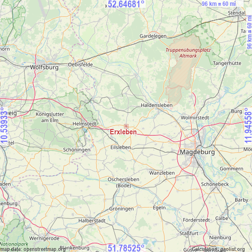
Erxleben GPS coordinates[2]
52° 13' 5.232" North, 11° 14' 32.82" East
| Map corner | latitude | longitude |
|---|---|---|
| Upper-left | 52.64681°, | 10.53933° |
| Center: | 52.21812°, | 11.24245° |
| Lower-right: | 51.78525°, | 11.94558° |
| Map W x H: | 95.8×95.8 km | = 59.5×59.5mi |
| max Lat: | 55.01917° ⇑25.7% North |
| Erxleben: | 52.21812° |
| min Lat: | ⇓74.3% South 47.40724° |
| min Long | Erxleben | max Long |
| 5.92978° | 11.24245° | 14.98853° |
| W 70.5%⇐ | ⇒29.5% E |
Elevation
Elevation of Erxleben is 141 m = 463 ft, and this is 108.1 m = 355 ft below average elevation for this country.
| Max E: |
1256 m = 4121 ft | 61.6% |
| Avg. | 249.1 m = 817 ft | |
| Erxleben | 141 m = 463 ft | |
Min E: |
-5 m = -16 ft | 38.4% |
See also: Germany elevation on elevation.city.
Geographical zone
Erxleben is located in North temperate zone (between Tropic of Cancer and the Arctic Circle). Distance of this North polar circle is 1595.1 km =991.1 mi to North.| Distance of | km | miles | from Erxleben |
|---|---|---|---|
| North Pole | 4201 | 2610.4 | to North |
| Arctic Circle | 1595.1 | 991.1 | to North |
| Tropic Cancer | 3200.2 | 1988.5 | to South |
| Equator | 5806.1 | 3607.7 | to South |


Nearby cities:
15 places around Erxleben: (largest is in red/bold)
• Altenhausen
4.9 km =3 mi,  9°
9°
• Beendorf
10.9 km =6.8 mi,  284°
284°
• Bregenstedt
4.2 km =2.6 mi,  341°
341°
• Eilsleben
8.2 km =5.1 mi,  195°
195°
• Eimersleben
2.9 km =1.8 mi, 278°
• Hakenstedt
4.3 km =2.7 mi,  160°
160°
• Hörsingen
9.1 km =5.7 mi,  318°
318°
• Ivenrode
6.1 km =3.8 mi,  352°
352°
• Marienborn
9.6 km =6 mi,  255°
255°
• Nordgermersleben
6.5 km =4 mi,  97°
97°
• Rottmersleben
10.7 km =6.6 mi,  93°
93°
• Süplingen
9.5 km =5.9 mi,  35°
35°
• Ummendorf
8 km =5 mi,  211°
211°
• Wefensleben
6.8 km =4.2 mi,  235°
235°
• Wormsdorf
10 km =6.2 mi, 199°
Sources, notices
• [Note1] Compared only with cities in Germany existing in our database
• [Src1] Map data: © OpenStreetMap contributors (CC-BY-SA)
• [Src2] Other city data from geonames.org with taken over terms of usage.
• [Src3] Geographical zone / Annual Mean Temperature by Robert A. Rohde @ Wikipedia
