Süplingen geodata
Süplingen (Saxony-Anhalt) is a seat of a fourth-order administrative division; located in Germany in Europe/Berlin (GMT+2) time zone. With population of 1,065 people, there are 6948 cities with bigger population in this country. Compared to other cities in Germany, 75% of cities are located further ↓South; 71.6% of cities are located further ←West and 70% of cities have higher elevation than Süplingen. Note1


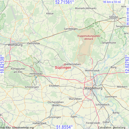
Süplingen GPS coordinates[2]
52° 17' 15.324" North, 11° 19' 28.2" East
| Map corner | latitude | longitude |
|---|---|---|
| Upper-left | 52.71561°, | 10.62138° |
| Center: | 52.28759°, | 11.3245° |
| Lower-right: | 51.8554°, | 12.02763° |
| Map W x H: | 95.6×95.6 km | = 59.4×59.4mi |
| max Lat: | 55.01917° ⇑25% North |
| Süplingen: | 52.28759° |
| min Lat: | ⇓75% South 47.40724° |
| min Long | Süplingen | max Long |
| 5.92978° | 11.3245° | 14.98853° |
| W 71.6%⇐ | ⇒28.4% E |
Elevation
Elevation of Süplingen is 91 m = 299 ft, and this is 158.1 m = 519 ft below average elevation for this country.
| Max E: |
1256 m = 4121 ft | 70% |
| Avg. | 249.1 m = 817 ft | |
| Süplingen | 91 m = 299 ft | |
Min E: |
-5 m = -16 ft | 30% |
See also: Germany elevation on elevation.city.
Geographical zone
Süplingen is located in North temperate zone (between Tropic of Cancer and the Arctic Circle). Distance of this North polar circle is 1587.3 km =986.3 mi to North.| Distance of | km | miles | from Süplingen |
|---|---|---|---|
| North Pole | 4193.2 | 2605.5 | to North |
| Arctic Circle | 1587.3 | 986.3 | to North |
| Tropic Cancer | 3207.9 | 1993.3 | to South |
| Equator | 5813.8 | 3612.5 | to South |


Nearby cities:
15 places around Süplingen: (largest is in red/bold)
• Altenhausen
5.6 km =3.5 mi,  239°
239°
• Behnsdorf
12.1 km =7.5 mi,  284°
284°
• Bregenstedt
7.9 km =4.9 mi, 241°
• Bülstringen
3.7 km =2.3 mi,  28°
28°
• Eimersleben
11.2 km =7 mi,  229°
229°
• Erxleben
9.5 km =5.9 mi,  215°
215°
• Flechtingen
7.4 km =4.6 mi,  310°
310°
• Haldensleben I
5.8 km =3.6 mi,  88°
88°
• Hillersleben
10.5 km =6.5 mi, 93°
• Hörsingen
11.6 km =7.2 mi,  265°
265°
• Ivenrode
6.6 km =4.1 mi,  255°
255°
• Neuenhofe
9.5 km =5.9 mi,  79°
79°
• Nordgermersleben
8.6 km =5.3 mi,  174°
174°
• Rottmersleben
9.7 km =6 mi,  148°
148°
• Schackensleben
12.1 km =7.5 mi, 147°
Sources, notices
• [Note1] Compared only with cities in Germany existing in our database
• [Src1] Map data: © OpenStreetMap contributors (CC-BY-SA)
• [Src2] Other city data from geonames.org with taken over terms of usage.
• [Src3] Geographical zone / Annual Mean Temperature by Robert A. Rohde @ Wikipedia
