Altenhausen geodata
Altenhausen (Saxony-Anhalt) is a seat of a fourth-order administrative division; located in Germany in Europe/Berlin (GMT+2) time zone. With population of 383 people, there are 9744 cities with bigger population in this country. Compared to other cities in Germany, 74.8% of cities are located further ↓South; 70.7% of cities are located further ←West and 61.3% of cities have higher elevation than Altenhausen. Note1


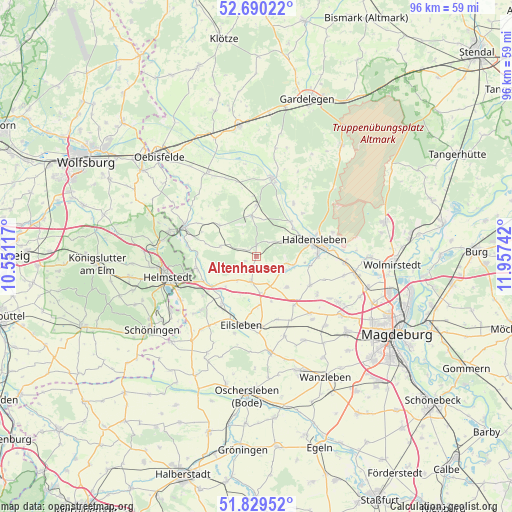
Altenhausen GPS coordinates[2]
52° 15' 43.056" North, 11° 15' 15.444" East
| Map corner | latitude | longitude |
|---|---|---|
| Upper-left | 52.69022°, | 10.55117° |
| Center: | 52.26196°, | 11.25429° |
| Lower-right: | 51.82952°, | 11.95742° |
| Map W x H: | 95.7×95.7 km | = 59.5×59.5mi |
| max Lat: | 55.01917° ⇑25.2% North |
| Altenhausen: | 52.26196° |
| min Lat: | ⇓74.8% South 47.40724° |
| min Long | Altenhausen | max Long |
| 5.92978° | 11.25429° | 14.98853° |
| W 70.7%⇐ | ⇒29.3% E |
Elevation
Elevation of Altenhausen is 144 m = 472 ft, and this is 105.1 m = 345 ft below average elevation for this country.
| Max E: |
1256 m = 4121 ft | 61.3% |
| Avg. | 249.1 m = 817 ft | |
| Altenhausen | 144 m = 472 ft | |
Min E: |
-5 m = -16 ft | 38.7% |
See also: Germany elevation on elevation.city.
Geographical zone
Altenhausen is located in North temperate zone (between Tropic of Cancer and the Arctic Circle). Distance of this North polar circle is 1590.2 km =988.1 mi to North.| Distance of | km | miles | from Altenhausen |
|---|---|---|---|
| North Pole | 4196.1 | 2607.3 | to North |
| Arctic Circle | 1590.2 | 988.1 | to North |
| Tropic Cancer | 3205.1 | 1991.6 | to South |
| Equator | 5811 | 3610.8 | to South |


Nearby cities:
15 places around Altenhausen: (largest is in red/bold)
• Beendorf
11.6 km =7.2 mi,  259°
259°
• Behnsdorf
9.2 km =5.7 mi,  310°
310°
• Bregenstedt
2.3 km =1.4 mi,  247°
247°
• Bülstringen
8.9 km =5.5 mi,  46°
46°
• Eimersleben
5.8 km =3.6 mi,  219°
219°
• Erxleben
4.9 km =3 mi,  189°
189°
• Flechtingen
7.7 km =4.8 mi,  353°
353°
• Hakenstedt
9 km =5.6 mi,  176°
176°
• Haldensleben I
11 km =6.8 mi,  74°
74°
• Hörsingen
7.1 km =4.4 mi,  285°
285°
• Ivenrode
2 km =1.2 mi, 307°
• Nordgermersleben
8 km =5 mi,  135°
135°
• Rottmersleben
11.3 km =7 mi,  118°
118°
• Süplingen
5.6 km =3.5 mi,  59°
59°
• Wefensleben
10.8 km =6.7 mi, 216°
Sources, notices
• [Note1] Compared only with cities in Germany existing in our database
• [Src1] Map data: © OpenStreetMap contributors (CC-BY-SA)
• [Src2] Other city data from geonames.org with taken over terms of usage.
• [Src3] Geographical zone / Annual Mean Temperature by Robert A. Rohde @ Wikipedia
