Elmenhorst geodata
Elmenhorst (Mecklenburg-Vorpommern) is a populated place; located in Germany in Europe/Berlin (GMT+2) time zone. With population of 824 people, there are 7807 cities with bigger population in this country. Compared to other cities in Germany, 95.3% of cities are located further ↓South; 92.8% of cities are located further ←West and 88% of cities have higher elevation than Elmenhorst. Note1
Administrative division(s):
- Level 1: Mecklenburg-Vorpommern
- Level 3: Vorpommern-Rügen
- Level 4: Elmenhorst


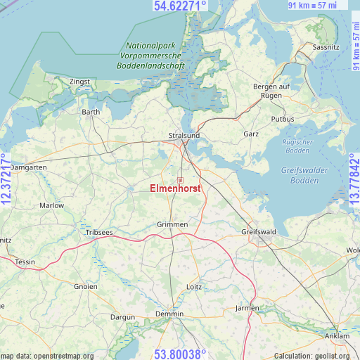
Elmenhorst GPS coordinates[2]
54° 12' 48.924" North, 13° 4' 31.044" East
| Map corner | latitude | longitude |
|---|---|---|
| Upper-left | 54.62271°, | 12.37217° |
| Center: | 54.21359°, | 13.07529° |
| Lower-right: | 53.80038°, | 13.77842° |
| Map W x H: | 91.4×91.4 km | = 56.8×56.8mi |
| max Lat: | 55.01917° ⇑4.7% North |
| Elmenhorst: | 54.21359° |
| min Lat: | ⇓95.3% South 47.40724° |
| min Long | Elmenhorst | max Long |
| 5.92978° | 13.07529° | 14.98853° |
| W 92.8%⇐ | ⇒7.2% E |
Elevation
Elevation of Elmenhorst is 27 m = 89 ft, and this is 222.1 m = 729 ft below average elevation for this country.
| Max E: |
1256 m = 4121 ft | 88% |
| Avg. | 249.1 m = 817 ft | |
| Elmenhorst | 27 m = 89 ft | |
Min E: |
-5 m = -16 ft | 12% |
See also: Germany elevation on elevation.city.
Geographical zone
Elmenhorst is located in North temperate zone (between Tropic of Cancer and the Arctic Circle). Distance of this North polar circle is 1373.2 km =853.3 mi to North.| Distance of | km | miles | from Elmenhorst |
|---|---|---|---|
| North Pole | 3979.1 | 2472.5 | to North |
| Arctic Circle | 1373.2 | 853.3 | to North |
| Tropic Cancer | 3422.1 | 2126.4 | to South |
| Equator | 6028 | 3745.6 | to South |


Nearby cities:
15 places around Elmenhorst: (largest is in red/bold)
• Altefähr
13.4 km =8.3 mi,  14°
14°
• Brandshagen
6.7 km =4.2 mi,  64°
64°
• Franzburg
13 km =8.1 mi,  255°
255°
• Grimmen
11.5 km =7.1 mi,  191°
191°
• Jakobsdorf
9.6 km =6 mi,  283°
283°
• Kirchdorf
13.7 km =8.5 mi,  108°
108°
• Lüssow
8.1 km =5 mi,  339°
339°
• Pantelitz
12 km =7.5 mi,  324°
324°
• Richtenberg
11.9 km =7.4 mi, 263°
• Steinhagen
5.8 km =3.6 mi, 283°
• Stoltenhagen
6.3 km =3.9 mi,  177°
177°
• Stralsund
10.6 km =6.6 mi,  2°
2°
• Wendorf
4.6 km =2.9 mi, 1°
• Wittenhagen
3.3 km =2.1 mi, 184°
• Zarrendorf
3.1 km =1.9 mi,  32°
32°
Sources, notices
• [Note1] Compared only with cities in Germany existing in our database
• [Src1] Map data: © OpenStreetMap contributors (CC-BY-SA)
• [Src2] Other city data from geonames.org with taken over terms of usage.
• [Src3] Geographical zone / Annual Mean Temperature by Robert A. Rohde @ Wikipedia
