Brandshagen geodata
Brandshagen (Mecklenburg-Vorpommern) is a populated place; located in Germany in Europe/Berlin (GMT+2) time zone. With population of 1,315 people, there are 6264 cities with bigger population in this country. Compared to other cities in Germany, 95.7% of cities are located further ↓South; 93.5% of cities are located further ←West and 90.1% of cities have higher elevation than Brandshagen. Note1
Administrative division(s):
- Level 1: Mecklenburg-Vorpommern
- Level 3: Vorpommern-Rügen
- Level 4: Sundhagen


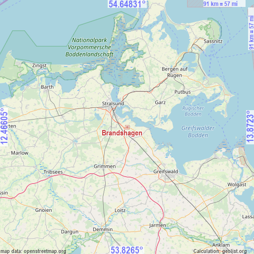
Brandshagen GPS coordinates[2]
54° 14' 22.02" North, 13° 10' 9.012" East
| Map corner | latitude | longitude |
|---|---|---|
| Upper-left | 54.64831°, | 12.46605° |
| Center: | 54.23945°, | 13.16917° |
| Lower-right: | 53.8265°, | 13.8723° |
| Map W x H: | 91.4×91.4 km | = 56.8×56.8mi |
| max Lat: | 55.01917° ⇑4.3% North |
| Brandshagen: | 54.23945° |
| min Lat: | ⇓95.7% South 47.40724° |
| min Long | Brandshagen | max Long |
| 5.92978° | 13.16917° | 14.98853° |
| W 93.5%⇐ | ⇒6.5% E |
Elevation
Elevation of Brandshagen is 21 m = 69 ft, and this is 228.1 m = 748 ft below average elevation for this country.
| Max E: |
1256 m = 4121 ft | 90.1% |
| Avg. | 249.1 m = 817 ft | |
| Brandshagen | 21 m = 69 ft | |
Min E: |
-5 m = -16 ft | 9.9% |
See also: Germany elevation on elevation.city.
Geographical zone
Brandshagen is located in North temperate zone (between Tropic of Cancer and the Arctic Circle). Distance of this North polar circle is 1370.3 km =851.5 mi to North.| Distance of | km | miles | from Brandshagen |
|---|---|---|---|
| North Pole | 3976.2 | 2470.7 | to North |
| Arctic Circle | 1370.3 | 851.5 | to North |
| Tropic Cancer | 3424.9 | 2128.1 | to South |
| Equator | 6030.9 | 3747.4 | to South |


Nearby cities:
15 places around Brandshagen: (largest is in red/bold)
• Altefähr
10.4 km =6.5 mi,  344°
344°
• Elmenhorst
6.7 km =4.2 mi,  244°
244°
• Garz
14.7 km =9.1 mi,  53°
53°
• Kirchdorf
9.9 km =6.2 mi,  136°
136°
• Lüssow
10.1 km =6.3 mi,  297°
297°
• Mesekenhagen
14 km =8.7 mi, 136°
• Pantelitz
14.7 km =9.1 mi, 297°
• Poseritz
9.5 km =5.9 mi, 46°
• Rambin
13.1 km =8.1 mi,  10°
10°
• Steinhagen
11.8 km =7.3 mi,  262°
262°
• Stoltenhagen
10.9 km =6.8 mi,  212°
212°
• Stralsund
9.6 km =6 mi,  323°
323°
• Wendorf
6.3 km =3.9 mi,  286°
286°
• Wittenhagen
8.9 km =5.5 mi,  225°
225°
• Zarrendorf
4.4 km =2.7 mi,  266°
266°
Sources, notices
• [Note1] Compared only with cities in Germany existing in our database
• [Src1] Map data: © OpenStreetMap contributors (CC-BY-SA)
• [Src2] Other city data from geonames.org with taken over terms of usage.
• [Src3] Geographical zone / Annual Mean Temperature by Robert A. Rohde @ Wikipedia
