Halle geodata
Halle (Lower Saxony) is a seat of a fourth-order administrative division; located in Germany in Europe/Berlin (GMT+2) time zone. With population of 1,779 people, there are 5377 cities with bigger population in this country. Compared to other cities in Germany, 72.1% of cities are located further ↓South; 56.8% of cities are located further →East and 69.2% of cities have higher elevation than Halle. Note1


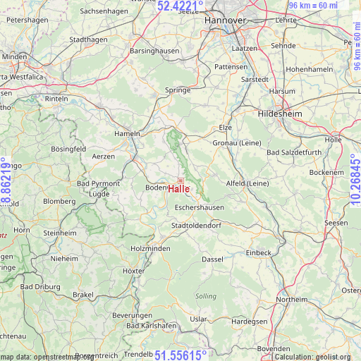
Halle GPS coordinates[2]
51° 59' 28.392" North, 9° 33' 55.152" East
| Map corner | latitude | longitude |
|---|---|---|
| Upper-left | 52.4221°, | 8.86219° |
| Center: | 51.99122°, | 9.56532° |
| Lower-right: | 51.55615°, | 10.26845° |
| Map W x H: | 96.3×96.3 km | = 59.8×59.8mi |
| max Lat: | 55.01917° ⇑27.9% North |
| Halle: | 51.99122° |
| min Lat: | ⇓72.1% South 47.40724° |
| min Long | Halle | max Long |
| 5.92978° | 9.56532° | 14.98853° |
| W 43.2%⇐ | ⇒56.8% E |
Elevation
Elevation of Halle is 96 m = 315 ft, and this is 153.1 m = 502 ft below average elevation for this country.
| Max E: |
1256 m = 4121 ft | 69.2% |
| Avg. | 249.1 m = 817 ft | |
| Halle | 96 m = 315 ft | |
Min E: |
-5 m = -16 ft | 30.8% |
See also: Germany elevation on elevation.city.
Geographical zone
Halle is located in North temperate zone (between Tropic of Cancer and the Arctic Circle). Distance of this North polar circle is 1620.3 km =1006.8 mi to North.| Distance of | km | miles | from Halle |
|---|---|---|---|
| North Pole | 4226.2 | 2626 | to North |
| Arctic Circle | 1620.3 | 1006.8 | to North |
| Tropic Cancer | 3175 | 1972.9 | to South |
| Equator | 5780.9 | 3592.1 | to South |


Nearby cities:
15 places around Halle: (largest is in red/bold)
• Bodenwerder
3.8 km =2.4 mi,  235°
235°
• Dielmissen
3.6 km =2.2 mi,  128°
128°
• Duingen
9.1 km =5.7 mi,  80°
80°
• Eschershausen
8.9 km =5.5 mi,  143°
143°
• Golmbach
10.2 km =6.3 mi,  185°
185°
• Hehlen
6.5 km =4 mi,  267°
267°
• Heyen
4.7 km =2.9 mi,  295°
295°
• Holenberg
8.4 km =5.2 mi,  171°
171°
• Holzen
9.5 km =5.9 mi, 132°
• Kirchbrak
2.9 km =1.8 mi, 166°
• Lüerdissen
5.9 km =3.7 mi, 136°
• Marienhagen
9.8 km =6.1 mi,  58°
58°
• Pegestorf
8.5 km =5.3 mi,  213°
213°
• Salzhemmendorf
8.6 km =5.3 mi,  10°
10°
• Weenzen
8.4 km =5.2 mi, 55°
Sources, notices
• [Note1] Compared only with cities in Germany existing in our database
• [Src1] Map data: © OpenStreetMap contributors (CC-BY-SA)
• [Src2] Other city data from geonames.org with taken over terms of usage.
• [Src3] Geographical zone / Annual Mean Temperature by Robert A. Rohde @ Wikipedia
