Dielmissen geodata
Dielmissen (Lower Saxony) is a seat of a fourth-order administrative division; located in Germany in Europe/Berlin (GMT+2) time zone. With population of 866 people, there are 7640 cities with bigger population in this country. Compared to other cities in Germany, 71.9% of cities are located further ↓South; 56% of cities are located further →East and 61.6% of cities have higher elevation than Dielmissen. Note1


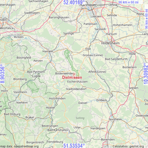
Dielmissen GPS coordinates[2]
51° 58' 14.196" North, 9° 36' 24.084" East
| Map corner | latitude | longitude |
|---|---|---|
| Upper-left | 52.40169°, | 8.90356° |
| Center: | 51.97061°, | 9.60669° |
| Lower-right: | 51.53534°, | 10.30982° |
| Map W x H: | 96.3×96.3 km | = 59.8×59.8mi |
| max Lat: | 55.01917° ⇑28.1% North |
| Dielmissen: | 51.97061° |
| min Lat: | ⇓71.9% South 47.40724° |
| min Long | Dielmissen | max Long |
| 5.92978° | 9.60669° | 14.98853° |
| W 44%⇐ | ⇒56% E |
Elevation
Elevation of Dielmissen is 141 m = 463 ft, and this is 108.1 m = 355 ft below average elevation for this country.
| Max E: |
1256 m = 4121 ft | 61.6% |
| Avg. | 249.1 m = 817 ft | |
| Dielmissen | 141 m = 463 ft | |
Min E: |
-5 m = -16 ft | 38.4% |
See also: Germany elevation on elevation.city.
Geographical zone
Dielmissen is located in North temperate zone (between Tropic of Cancer and the Arctic Circle). Distance of this North polar circle is 1622.6 km =1008.2 mi to North.| Distance of | km | miles | from Dielmissen |
|---|---|---|---|
| North Pole | 4228.5 | 2627.5 | to North |
| Arctic Circle | 1622.6 | 1008.2 | to North |
| Tropic Cancer | 3172.7 | 1971.4 | to South |
| Equator | 5778.6 | 3590.7 | to South |


Nearby cities:
15 places around Dielmissen: (largest is in red/bold)
• Bodenwerder
6 km =3.7 mi,  271°
271°
• Coppengrave
8.8 km =5.5 mi,  80°
80°
• Duingen
7.2 km =4.5 mi,  58°
58°
• Eschershausen
5.5 km =3.4 mi,  153°
153°
• Golmbach
8.8 km =5.5 mi,  206°
206°
• Halle
3.6 km =2.2 mi,  308°
308°
• Hehlen
9.6 km =6 mi,  282°
282°
• Heyen
8.3 km =5.2 mi,  301°
301°
• Holenberg
6.2 km =3.9 mi,  194°
194°
• Holzen
5.8 km =3.6 mi,  135°
135°
• Kirchbrak
2.2 km =1.4 mi,  256°
256°
• Lüerdissen
2.3 km =1.4 mi, 148°
• Marienhagen
9.2 km =5.7 mi,  36°
36°
• Pegestorf
8.9 km =5.5 mi,  237°
237°
• Weenzen
8.1 km =5 mi,  30°
30°
Sources, notices
• [Note1] Compared only with cities in Germany existing in our database
• [Src1] Map data: © OpenStreetMap contributors (CC-BY-SA)
• [Src2] Other city data from geonames.org with taken over terms of usage.
• [Src3] Geographical zone / Annual Mean Temperature by Robert A. Rohde @ Wikipedia
