Dreschvitz geodata
Dreschvitz (Mecklenburg-Vorpommern) is a populated place; located in Germany in Europe/Berlin (GMT+2) time zone. With population of 796 people, there are 7917 cities with bigger population in this country. Compared to other cities in Germany, 97.5% of cities are located further ↓South; 94.3% of cities are located further ←West and 94.8% of cities have higher elevation than Dreschvitz. Note1
Administrative division(s):
- Level 1: Mecklenburg-Vorpommern
- Level 3: Vorpommern-Rügen
- Level 4: Dreschvitz


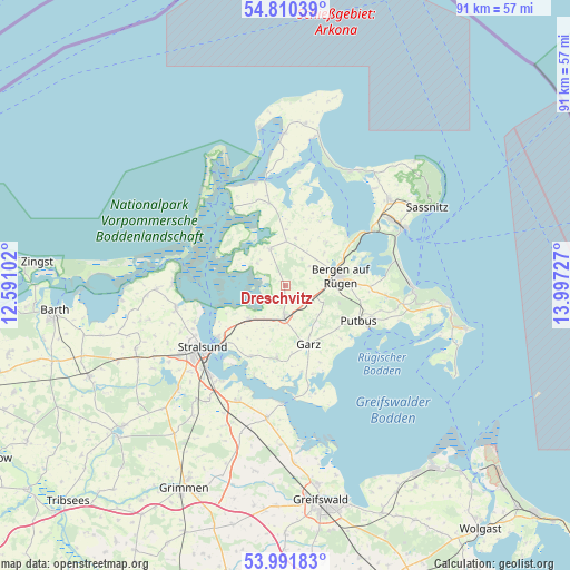
Dreschvitz GPS coordinates[2]
54° 24' 11.34" North, 13° 17' 38.904" East
| Map corner | latitude | longitude |
|---|---|---|
| Upper-left | 54.81039°, | 12.59102° |
| Center: | 54.40315°, | 13.29414° |
| Lower-right: | 53.99183°, | 13.99727° |
| Map W x H: | 91×91 km | = 56.5×56.5mi |
| max Lat: | 55.01917° ⇑2.5% North |
| Dreschvitz: | 54.40315° |
| min Lat: | ⇓97.5% South 47.40724° |
| min Long | Dreschvitz | max Long |
| 5.92978° | 13.29414° | 14.98853° |
| W 94.3%⇐ | ⇒5.7% E |
Elevation
Elevation of Dreschvitz is 9 m = 30 ft, and this is 240.1 m = 788 ft below average elevation for this country.
| Max E: |
1256 m = 4121 ft | 94.8% |
| Avg. | 249.1 m = 817 ft | |
| Dreschvitz | 9 m = 30 ft | |
Min E: |
-5 m = -16 ft | 5.2% |
See also: Germany elevation on elevation.city.
Geographical zone
Dreschvitz is located in North temperate zone (between Tropic of Cancer and the Arctic Circle). Distance of this North polar circle is 1352.1 km =840.2 mi to North.| Distance of | km | miles | from Dreschvitz |
|---|---|---|---|
| North Pole | 3958 | 2459.4 | to North |
| Arctic Circle | 1352.1 | 840.2 | to North |
| Tropic Cancer | 3443.1 | 2139.4 | to South |
| Equator | 6049.1 | 3758.7 | to South |


Nearby cities:
15 places around Dreschvitz: (largest is in red/bold)
• Altefähr
13.6 km =8.5 mi,  233°
233°
• Bergen auf Rügen
9.2 km =5.7 mi,  79°
79°
• Garz
10.1 km =6.3 mi,  158°
158°
• Gingst
6.4 km =4 mi,  338°
338°
• Kramerhof
16.5 km =10.3 mi,  250°
250°
• Parchtitz
7.8 km =4.8 mi,  60°
60°
• Patzig
9.5 km =5.9 mi,  43°
43°
• Poseritz
11.7 km =7.3 mi,  186°
186°
• Putbus
13 km =8.1 mi,  114°
114°
• Rambin
7.8 km =4.8 mi, 227°
• Samtens
5.4 km =3.4 mi,  180°
180°
• Schaprode
14.8 km =9.2 mi,  326°
326°
• Sehlen
6.7 km =4.2 mi, 112°
• Trent
13.3 km =8.3 mi,  349°
349°
• Ummanz
6.9 km =4.3 mi,  310°
310°
Sources, notices
• [Note1] Compared only with cities in Germany existing in our database
• [Src1] Map data: © OpenStreetMap contributors (CC-BY-SA)
• [Src2] Other city data from geonames.org with taken over terms of usage.
• [Src3] Geographical zone / Annual Mean Temperature by Robert A. Rohde @ Wikipedia
