Samtens geodata
Samtens (Mecklenburg-Vorpommern) is a populated place; located in Germany in Europe/Berlin (GMT+2) time zone. With population of 2,085 people, there are 4946 cities with bigger population in this country. Compared to other cities in Germany, 96.9% of cities are located further ↓South; 94.3% of cities are located further ←West and 96.6% of cities have higher elevation than Samtens. Note1
Administrative division(s):
- Level 1: Mecklenburg-Vorpommern
- Level 3: Vorpommern-Rügen
- Level 4: Samtens


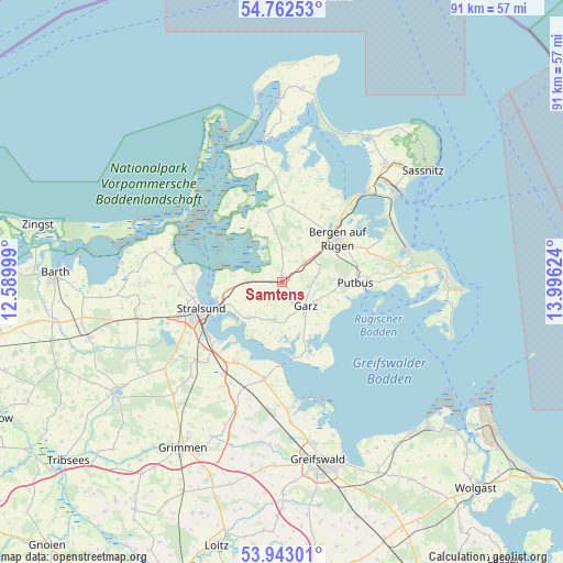
Samtens GPS coordinates[2]
54° 21' 17.316" North, 13° 17' 35.196" East
| Map corner | latitude | longitude |
|---|---|---|
| Upper-left | 54.76253°, | 12.58999° |
| Center: | 54.35481°, | 13.29311° |
| Lower-right: | 53.94301°, | 13.99624° |
| Map W x H: | 91.1×91.1 km | = 56.6×56.6mi |
| max Lat: | 55.01917° ⇑3.1% North |
| Samtens: | 54.35481° |
| min Lat: | ⇓96.9% South 47.40724° |
| min Long | Samtens | max Long |
| 5.92978° | 13.29311° | 14.98853° |
| W 94.3%⇐ | ⇒5.7% E |
Elevation
Elevation of Samtens is 5 m = 16 ft, and this is 244.1 m = 801 ft below average elevation for this country.
| Max E: |
1256 m = 4121 ft | 96.6% |
| Avg. | 249.1 m = 817 ft | |
| Samtens | 5 m = 16 ft | |
Min E: |
-5 m = -16 ft | 3.4% |
See also: Germany elevation on elevation.city.
Geographical zone
Samtens is located in North temperate zone (between Tropic of Cancer and the Arctic Circle). Distance of this North polar circle is 1357.5 km =843.5 mi to North.| Distance of | km | miles | from Samtens |
|---|---|---|---|
| North Pole | 3963.4 | 2462.7 | to North |
| Arctic Circle | 1357.5 | 843.5 | to North |
| Tropic Cancer | 3437.8 | 2136.1 | to South |
| Equator | 6043.7 | 3755.4 | to South |


Nearby cities:
15 places around Samtens: (largest is in red/bold)
• Altefähr
11.2 km =7 mi,  255°
255°
• Bergen auf Rügen
11.5 km =7.1 mi,  52°
52°
• Brandshagen
15.1 km =9.4 mi,  212°
212°
• Dreschvitz
5.4 km =3.4 mi,  0°
0°
• Garz
5.5 km =3.4 mi,  137°
137°
• Gingst
11.5 km =7.1 mi,  348°
348°
• Kramerhof
15.5 km =9.6 mi,  269°
269°
• Parchtitz
11.5 km =7.1 mi,  36°
36°
• Patzig
13.9 km =8.6 mi,  28°
28°
• Poseritz
6.4 km =4 mi,  190°
190°
• Putbus
11.9 km =7.4 mi,  89°
89°
• Rambin
5.7 km =3.5 mi, 270°
• Sehlen
6.8 km =4.2 mi,  65°
65°
• Stralsund
14.6 km =9.1 mi,  249°
249°
• Ummanz
11.1 km =6.9 mi,  332°
332°
Sources, notices
• [Note1] Compared only with cities in Germany existing in our database
• [Src1] Map data: © OpenStreetMap contributors (CC-BY-SA)
• [Src2] Other city data from geonames.org with taken over terms of usage.
• [Src3] Geographical zone / Annual Mean Temperature by Robert A. Rohde @ Wikipedia
