Dieskau geodata
Dieskau (Saxony-Anhalt) is a populated place; located in Germany in Europe/Berlin (GMT+2) time zone. With population of 3,133 people, there are 3884 cities with bigger population in this country. Compared to other cities in Germany, 65.4% of cities are located further ↓South; 82.3% of cities are located further ←West and 69.2% of cities have higher elevation than Dieskau. Note1


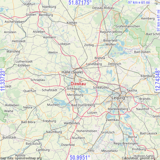
Dieskau GPS coordinates[2]
51° 26' 7.908" North, 12° 2' 25.26" East
| Map corner | latitude | longitude |
|---|---|---|
| Upper-left | 51.87175°, | 11.33723° |
| Center: | 51.43553°, | 12.04035° |
| Lower-right: | 50.9951°, | 12.74348° |
| Map W x H: | 97.5×97.5 km | = 60.6×60.6mi |
| max Lat: | 55.01917° ⇑34.6% North |
| Dieskau: | 51.43553° |
| min Lat: | ⇓65.4% South 47.40724° |
| min Long | Dieskau | max Long |
| 5.92978° | 12.04035° | 14.98853° |
| W 82.3%⇐ | ⇒17.7% E |
Elevation
Elevation of Dieskau is 96 m = 315 ft, and this is 153.1 m = 502 ft below average elevation for this country.
| Max E: |
1256 m = 4121 ft | 69.2% |
| Avg. | 249.1 m = 817 ft | |
| Dieskau | 96 m = 315 ft | |
Min E: |
-5 m = -16 ft | 30.8% |
See also: Germany elevation on elevation.city.
Geographical zone
Dieskau is located in North temperate zone (between Tropic of Cancer and the Arctic Circle). Distance of this North polar circle is 1682.1 km =1045.2 mi to North.| Distance of | km | miles | from Dieskau |
|---|---|---|---|
| North Pole | 4288 | 2664.4 | to North |
| Arctic Circle | 1682.1 | 1045.2 | to North |
| Tropic Cancer | 3113.2 | 1934.5 | to South |
| Equator | 5719.1 | 3553.7 | to South |


Nearby cities:
15 places around Dieskau: (largest is in red/bold)
• Angersdorf
9.6 km =6 mi,  286°
286°
• Dölbau
3.7 km =2.3 mi,  18°
18°
• Döllnitz
3.2 km =2 mi,  195°
195°
• Ermlitz
9.6 km =6 mi,  120°
120°
• Großkugel
7.6 km =4.7 mi,  105°
105°
• Gröbers
5.3 km =3.3 mi,  96°
96°
• Halle (Saale)
6.6 km =4.1 mi,  320°
320°
• Hohenweiden
7.3 km =4.5 mi,  255°
255°
• Lochau
4.3 km =2.7 mi,  168°
168°
• Peißen
7.6 km =4.7 mi,  8°
8°
• Queis
7.9 km =4.9 mi,  55°
55°
• Raßnitz
6.2 km =3.9 mi,  143°
143°
• Reußen
9.6 km =6 mi,  40°
40°
• Schkopau
7.8 km =4.8 mi,  231°
231°
• Wallendorf
8.8 km =5.5 mi,  163°
163°
Sources, notices
• [Note1] Compared only with cities in Germany existing in our database
• [Src1] Map data: © OpenStreetMap contributors (CC-BY-SA)
• [Src2] Other city data from geonames.org with taken over terms of usage.
• [Src3] Geographical zone / Annual Mean Temperature by Robert A. Rohde @ Wikipedia
