Angersdorf geodata
Angersdorf (Saxony-Anhalt) is a populated place; located in Germany in Europe/Berlin (GMT+2) time zone. With population of 1,237 people, there are 6476 cities with bigger population in this country. Compared to other cities in Germany, 65.7% of cities are located further ↓South; 80.4% of cities are located further ←West and 70.5% of cities have higher elevation than Angersdorf. Note1


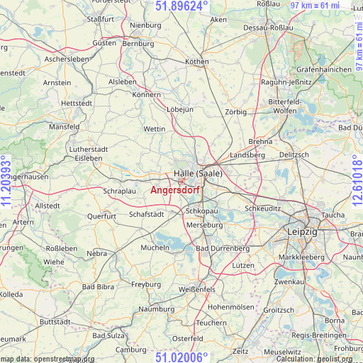
Angersdorf GPS coordinates[2]
51° 27' 36.9" North, 11° 54' 25.38" East
| Map corner | latitude | longitude |
|---|---|---|
| Upper-left | 51.89624°, | 11.20393° |
| Center: | 51.46025°, | 11.90705° |
| Lower-right: | 51.02006°, | 12.61018° |
| Map W x H: | 97.4×97.4 km | = 60.5×60.5mi |
| max Lat: | 55.01917° ⇑34.3% North |
| Angersdorf: | 51.46025° |
| min Lat: | ⇓65.7% South 47.40724° |
| min Long | Angersdorf | max Long |
| 5.92978° | 11.90705° | 14.98853° |
| W 80.4%⇐ | ⇒19.6% E |
Elevation
Elevation of Angersdorf is 88 m = 289 ft, and this is 161.1 m = 529 ft below average elevation for this country.
| Max E: |
1256 m = 4121 ft | 70.5% |
| Avg. | 249.1 m = 817 ft | |
| Angersdorf | 88 m = 289 ft | |
Min E: |
-5 m = -16 ft | 29.5% |
See also: Germany elevation on elevation.city.
Geographical zone
Angersdorf is located in North temperate zone (between Tropic of Cancer and the Arctic Circle). Distance of this North polar circle is 1679.3 km =1043.5 mi to North.| Distance of | km | miles | from Angersdorf |
|---|---|---|---|
| North Pole | 4285.2 | 2662.7 | to North |
| Arctic Circle | 1679.3 | 1043.5 | to North |
| Tropic Cancer | 3115.9 | 1936.1 | to South |
| Equator | 5721.8 | 3555.4 | to South |


Nearby cities:
15 places around Angersdorf: (largest is in red/bold)
• Bad Lauchstädt
8.6 km =5.3 mi,  197°
197°
• Bennstedt
6.1 km =3.8 mi,  293°
293°
• Brachwitz
8.9 km =5.5 mi,  342°
342°
• Delitz am Berge
4.9 km =3 mi,  185°
185°
• Halle (Saale)
5.5 km =3.4 mi,  64°
64°
• Halle Neustadt
2.2 km =1.4 mi,  16°
16°
• Hohenweiden
5.1 km =3.2 mi,  154°
154°
• Holleben
2.3 km =1.4 mi, 193°
• Langenbogen
9.3 km =5.8 mi, 285°
• Lieskau
5.8 km =3.6 mi,  327°
327°
• Milzau
9.5 km =5.9 mi,  183°
183°
• Salzmünde
9.2 km =5.7 mi,  322°
322°
• Schkopau
8.2 km =5.1 mi,  157°
157°
• Teutschenthal
7.5 km =4.7 mi,  261°
261°
• Zscherben
2.6 km =1.6 mi, 286°
Sources, notices
• [Note1] Compared only with cities in Germany existing in our database
• [Src1] Map data: © OpenStreetMap contributors (CC-BY-SA)
• [Src2] Other city data from geonames.org with taken over terms of usage.
• [Src3] Geographical zone / Annual Mean Temperature by Robert A. Rohde @ Wikipedia
