Döllnitz geodata
Döllnitz (Saxony-Anhalt) is a populated place; located in Germany in Europe/Berlin (GMT+2) time zone. With population of 1,383 people, there are 6111 cities with bigger population in this country. Compared to other cities in Germany, 64.9% of cities are located further ↓South; 82.2% of cities are located further ←West and 71.1% of cities have higher elevation than Döllnitz. Note1


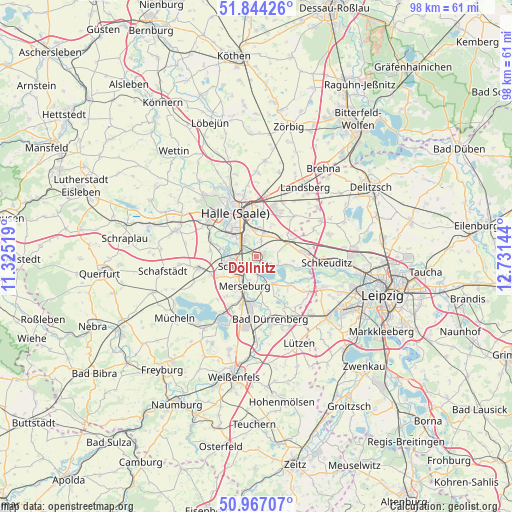
Döllnitz GPS coordinates[2]
51° 24' 27.972" North, 12° 1' 41.916" East
| Map corner | latitude | longitude |
|---|---|---|
| Upper-left | 51.84426°, | 11.32519° |
| Center: | 51.40777°, | 12.02831° |
| Lower-right: | 50.96707°, | 12.73144° |
| Map W x H: | 97.5×97.5 km | = 60.6×60.6mi |
| max Lat: | 55.01917° ⇑35.1% North |
| Döllnitz: | 51.40777° |
| min Lat: | ⇓64.9% South 47.40724° |
| min Long | Döllnitz | max Long |
| 5.92978° | 12.02831° | 14.98853° |
| W 82.2%⇐ | ⇒17.8% E |
Elevation
Elevation of Döllnitz is 84 m = 276 ft, and this is 165.1 m = 542 ft below average elevation for this country.
| Max E: |
1256 m = 4121 ft | 71.1% |
| Avg. | 249.1 m = 817 ft | |
| Döllnitz | 84 m = 276 ft | |
Min E: |
-5 m = -16 ft | 28.9% |
See also: Germany elevation on elevation.city.
Geographical zone
Döllnitz is located in North temperate zone (between Tropic of Cancer and the Arctic Circle). Distance of this North polar circle is 1685.2 km =1047.1 mi to North.| Distance of | km | miles | from Döllnitz |
|---|---|---|---|
| North Pole | 4291.1 | 2666.4 | to North |
| Arctic Circle | 1685.2 | 1047.1 | to North |
| Tropic Cancer | 3110.1 | 1932.5 | to South |
| Equator | 5716 | 3551.8 | to South |


Nearby cities:
15 places around Döllnitz: (largest is in red/bold)
• Delitz am Berge
8.9 km =5.5 mi,  276°
276°
• Dieskau
3.2 km =2 mi,  15°
15°
• Dölbau
6.9 km =4.3 mi, 16°
• Großkugel
8.3 km =5.2 mi,  82°
82°
• Gröbers
6.6 km =4.1 mi,  67°
67°
• Halle (Saale)
8.9 km =5.5 mi,  337°
337°
• Hohenweiden
6.4 km =4 mi, 281°
• Knapendorf
7.2 km =4.5 mi,  240°
240°
• Lochau
2.1 km =1.3 mi,  123°
123°
• Merseburg
6.5 km =4 mi,  204°
204°
• Raßnitz
4.9 km =3 mi,  112°
112°
• Schkopau
5.6 km =3.5 mi,  251°
251°
• Wallendorf
6.3 km =3.9 mi,  148°
148°
• Zscherben
9 km =5.6 mi,  206°
206°
• Zöschen
8.3 km =5.2 mi,  132°
132°
Sources, notices
• [Note1] Compared only with cities in Germany existing in our database
• [Src1] Map data: © OpenStreetMap contributors (CC-BY-SA)
• [Src2] Other city data from geonames.org with taken over terms of usage.
• [Src3] Geographical zone / Annual Mean Temperature by Robert A. Rohde @ Wikipedia
