Derschen geodata
Derschen (Rheinland-Pfalz) is a seat of a fourth-order administrative division; located in Germany in Europe/Berlin (GMT+2) time zone. With population of 1,086 people, there are 6893 cities with bigger population in this country. Compared to other cities in Germany, 52.5% of cities are located further ↓South; 77.5% of cities are located further →East and 79.9% of cities have lower elevation than Derschen. Note1
Administrative division(s):
- Level 1: Rheinland-Pfalz
- Level 3: Landkreis Altenkirchen
- Level 4: Derschen


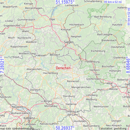
Derschen GPS coordinates[2]
50° 43' 0.012" North, 7° 58' 59.988" East
| Map corner | latitude | longitude |
|---|---|---|
| Upper-left | 51.15975°, | 7.28021° |
| Center: | 50.71667°, | 7.98333° |
| Lower-right: | 50.26937°, | 8.68646° |
| Map W x H: | 99×99 km | = 61.5×61.5mi |
| max Lat: | 55.01917° ⇑47.5% North |
| Derschen: | 50.71667° |
| min Lat: | ⇓52.5% South 47.40724° |
| min Long | Derschen | max Long |
| 5.92978° | 7.98333° | 14.98853° |
| W 22.5%⇐ | ⇒77.5% E |
Elevation
Elevation of Derschen is 432 m = 1417 ft, and this is 182.9 m = 600 ft above average elevation for this country.
| Max E: |
1256 m = 4121 ft | 20.1% |
| Derschen | 432 m 1417 ft | |
| Avg. | 249.1 m = 817 ft | |
Min E: |
-5 m = -16 ft | 79.9% |
See also: Germany elevation on elevation.city.
Geographical zone
Derschen is located in North temperate zone (between Tropic of Cancer and the Arctic Circle). Distance of this North polar circle is 1762 km =1094.9 mi to North.| Distance of | km | miles | from Derschen |
|---|---|---|---|
| North Pole | 4367.9 | 2714.1 | to North |
| Arctic Circle | 1762 | 1094.9 | to North |
| Tropic Cancer | 3033.2 | 1884.7 | to South |
| Equator | 5639.2 | 3504 | to South |


Nearby cities:
15 places around Derschen: (largest is in red/bold)
• Daaden
2.2 km =1.4 mi,  327°
327°
• Emmerzhausen
4.1 km =2.5 mi,  117°
117°
• Friedewald
1.7 km =1.1 mi,  248°
248°
• Herdorf
7 km =4.3 mi,  342°
342°
• Hof
6 km =3.7 mi,  157°
157°
• Kirburg
5.1 km =3.2 mi,  223°
223°
• Langenbach bei Kirburg
4 km =2.5 mi,  242°
242°
• Lautzenbrücken
5 km =3.1 mi,  195°
195°
• Mauden
1.2 km =0.7 mi,  90°
90°
• Neunkhausen
5.8 km =3.6 mi,  259°
259°
• Niederdreisbach
5.6 km =3.5 mi,  310°
310°
• Nisterberg
3.7 km =2.3 mi,  180°
180°
• Schutzbach
6.9 km =4.3 mi,  302°
302°
• Stein-Neukirch
6.8 km =4.2 mi,  131°
131°
• Weitefeld
4 km =2.5 mi,  284°
284°
Sources, notices
• [Note1] Compared only with cities in Germany existing in our database
• [Src1] Map data: © OpenStreetMap contributors (CC-BY-SA)
• [Src2] Other city data from geonames.org with taken over terms of usage.
• [Src3] Geographical zone / Annual Mean Temperature by Robert A. Rohde @ Wikipedia
