Weitefeld geodata
Weitefeld (Rheinland-Pfalz) is a seat of a fourth-order administrative division; located in Germany in Europe/Berlin (GMT+2) time zone. With population of 2,451 people, there are 4501 cities with bigger population in this country. Compared to other cities in Germany, 52.8% of cities are located further ↓South; 78.5% of cities are located further →East and 83.4% of cities have lower elevation than Weitefeld. Note1
Administrative division(s):
- Level 1: Rheinland-Pfalz
- Level 3: Landkreis Altenkirchen
- Level 4: Weitefeld


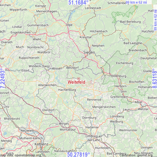
Weitefeld GPS coordinates[2]
50° 43' 31.476" North, 7° 55' 40.98" East
| Map corner | latitude | longitude |
|---|---|---|
| Upper-left | 51.1684°, | 7.22493° |
| Center: | 50.72541°, | 7.92805° |
| Lower-right: | 50.27819°, | 8.63118° |
| Map W x H: | 99×99 km | = 61.5×61.5mi |
| max Lat: | 55.01917° ⇑47.2% North |
| Weitefeld: | 50.72541° |
| min Lat: | ⇓52.8% South 47.40724° |
| min Long | Weitefeld | max Long |
| 5.92978° | 7.92805° | 14.98853° |
| W 21.5%⇐ | ⇒78.5% E |
Elevation
Elevation of Weitefeld is 457 m = 1499 ft, and this is 207.9 m = 682 ft above average elevation for this country.
| Max E: |
1256 m = 4121 ft | 16.6% |
| Weitefeld | 457 m 1499 ft | |
| Avg. | 249.1 m = 817 ft | |
Min E: |
-5 m = -16 ft | 83.4% |
See also: Germany elevation on elevation.city.
Geographical zone
Weitefeld is located in North temperate zone (between Tropic of Cancer and the Arctic Circle). Distance of this North polar circle is 1761 km =1094.2 mi to North.| Distance of | km | miles | from Weitefeld |
|---|---|---|---|
| North Pole | 4366.9 | 2713.5 | to North |
| Arctic Circle | 1761 | 1094.2 | to North |
| Tropic Cancer | 3034.2 | 1885.4 | to South |
| Equator | 5640.1 | 3504.6 | to South |


Nearby cities:
15 places around Weitefeld: (largest is in red/bold)
• Daaden
2.9 km =1.8 mi,  72°
72°
• Derschen
4 km =2.5 mi,  104°
104°
• Dickendorf
5.6 km =3.5 mi,  279°
279°
• Elkenroth
3.3 km =2.1 mi,  285°
285°
• Friedewald
2.8 km =1.7 mi,  125°
125°
• Kausen
4.6 km =2.9 mi, 292°
• Kirburg
4.7 km =2.9 mi,  175°
175°
• Langenbach bei Kirburg
2.8 km =1.7 mi,  172°
172°
• Mauden
5.2 km =3.2 mi, 100°
• Mörlen
4.3 km =2.7 mi,  225°
225°
• Nauroth
4.7 km =2.9 mi, 231°
• Neunkhausen
2.7 km =1.7 mi,  221°
221°
• Niederdreisbach
2.7 km =1.7 mi,  353°
353°
• Rosenheim
5.6 km =3.5 mi,  255°
255°
• Schutzbach
3.4 km =2.1 mi,  324°
324°
Sources, notices
• [Note1] Compared only with cities in Germany existing in our database
• [Src1] Map data: © OpenStreetMap contributors (CC-BY-SA)
• [Src2] Other city data from geonames.org with taken over terms of usage.
• [Src3] Geographical zone / Annual Mean Temperature by Robert A. Rohde @ Wikipedia
