Daun geodata
Daun (Rheinland-Pfalz) is a seat of a third-order administrative division; located in Germany in Europe/Berlin (GMT+2) time zone. With population of 8,523 people, there are 1870 cities with bigger population in this country. Compared to other cities in Germany, 59.1% of cities are located further ↑North; 95.3% of cities are located further →East and 79.9% of cities have lower elevation than Daun. Note1


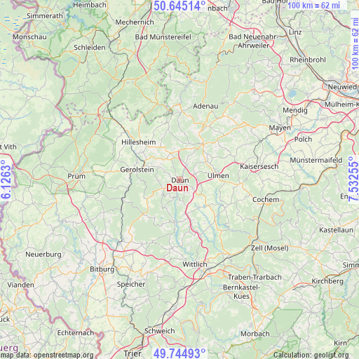
Daun GPS coordinates[2]
50° 11' 49.776" North, 6° 49' 45.912" East
| Map corner | latitude | longitude |
|---|---|---|
| Upper-left | 50.64514°, | 6.1263° |
| Center: | 50.19716°, | 6.82942° |
| Lower-right: | 49.74493°, | 7.53255° |
| Map W x H: | 100.1×100.1 km | = 62.2×62.2mi |
| max Lat: | 55.01917° ⇑59.1% North |
| Daun: | 50.19716° |
| min Lat: | ⇓40.9% South 47.40724° |
| min Long | Daun | max Long |
| 5.92978° | 6.82942° | 14.98853° |
| W 4.7%⇐ | ⇒95.3% E |
Elevation
Elevation of Daun is 432 m = 1417 ft, and this is 182.9 m = 600 ft above average elevation for this country.
| Max E: |
1256 m = 4121 ft | 20.1% |
| Daun | 432 m 1417 ft | |
| Avg. | 249.1 m = 817 ft | |
Min E: |
-5 m = -16 ft | 79.9% |
See also: Germany elevation on elevation.city.
Geographical zone
Daun is located in North temperate zone (between Tropic of Cancer and the Arctic Circle). Distance of this North polar circle is 1819.8 km =1130.8 mi to North.| Distance of | km | miles | from Daun |
|---|---|---|---|
| North Pole | 4425.7 | 2750 | to North |
| Arctic Circle | 1819.8 | 1130.8 | to North |
| Tropic Cancer | 2975.5 | 1848.9 | to South |
| Equator | 5581.4 | 3468.1 | to South |


Nearby cities:
15 places around Daun: (largest is in red/bold)
• Darscheid
4.4 km =2.7 mi,  60°
60°
• Dockweiler
6.7 km =4.2 mi,  330°
330°
• Hinterweiler
6.8 km =4.2 mi,  309°
309°
• Hörscheid
3.4 km =2.1 mi,  50°
50°
• Kradenbach
6.1 km =3.8 mi,  13°
13°
• Mehren
4.1 km =2.5 mi,  111°
111°
• Nerdlen
4.8 km =3 mi,  33°
33°
• Neroth
5.9 km =3.7 mi,  268°
268°
• Niederstadtfeld
6.4 km =4 mi,  230°
230°
• Oberstadtfeld
4.9 km =3 mi,  241°
241°
• Sarmersbach
5.6 km =3.5 mi,  43°
43°
• Schalkenmehren
4.2 km =2.6 mi,  147°
147°
• Steineberg
6.4 km =4 mi,  103°
103°
• Steiningen
6.4 km =4 mi, 103°
• Üdersdorf
5.6 km =3.5 mi,  201°
201°
Sources, notices
• [Note1] Compared only with cities in Germany existing in our database
• [Src1] Map data: © OpenStreetMap contributors (CC-BY-SA)
• [Src2] Other city data from geonames.org with taken over terms of usage.
• [Src3] Geographical zone / Annual Mean Temperature by Robert A. Rohde @ Wikipedia
