Neroth geodata
Neroth (Rheinland-Pfalz) is a seat of a fourth-order administrative division; located in Germany in Europe/Berlin (GMT+2) time zone. With population of 973 people, there are 7261 cities with bigger population in this country. Compared to other cities in Germany, 59.1% of cities are located further ↑North; 96.1% of cities are located further →East and 85.9% of cities have lower elevation than Neroth. Note1


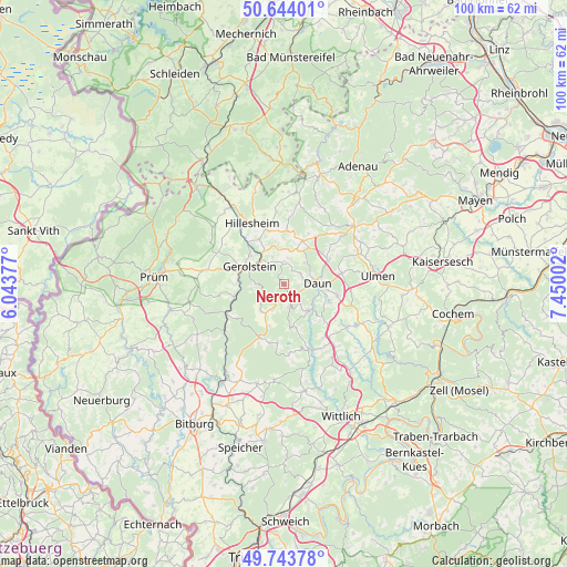
Neroth GPS coordinates[2]
50° 11' 45.672" North, 6° 44' 48.804" East
| Map corner | latitude | longitude |
|---|---|---|
| Upper-left | 50.64401°, | 6.04377° |
| Center: | 50.19602°, | 6.74689° |
| Lower-right: | 49.74378°, | 7.45002° |
| Map W x H: | 100.1×100.1 km | = 62.2×62.2mi |
| max Lat: | 55.01917° ⇑59.1% North |
| Neroth: | 50.19602° |
| min Lat: | ⇓40.9% South 47.40724° |
| min Long | Neroth | max Long |
| 5.92978° | 6.74689° | 14.98853° |
| W 3.9%⇐ | ⇒96.1% E |
Elevation
Elevation of Neroth is 477 m = 1565 ft, and this is 227.9 m = 748 ft above average elevation for this country.
| Max E: |
1256 m = 4121 ft | 14.1% |
| Neroth | 477 m 1565 ft | |
| Avg. | 249.1 m = 817 ft | |
Min E: |
-5 m = -16 ft | 85.9% |
See also: Germany elevation on elevation.city.
Geographical zone
Neroth is located in North temperate zone (between Tropic of Cancer and the Arctic Circle). Distance of this North polar circle is 1819.9 km =1130.8 mi to North.| Distance of | km | miles | from Neroth |
|---|---|---|---|
| North Pole | 4425.8 | 2750.1 | to North |
| Arctic Circle | 1819.9 | 1130.8 | to North |
| Tropic Cancer | 2975.4 | 1848.8 | to South |
| Equator | 5581.3 | 3468.1 | to South |


Nearby cities:
15 places around Neroth: (largest is in red/bold)
• Berlingen
5.2 km =3.2 mi,  337°
337°
• Betteldorf
6 km =3.7 mi,  2°
2°
• Daun
5.9 km =3.7 mi,  88°
88°
• Dockweiler
6.5 km =4 mi,  23°
23°
• Gerolstein
6.8 km =4.2 mi,  295°
295°
• Hinterweiler
4.5 km =2.8 mi,  8°
8°
• Hohenfels-Essingen
6.1 km =3.8 mi,  350°
350°
• Kirchweiler
3.8 km =2.4 mi,  358°
358°
• Niederstadtfeld
4.1 km =2.5 mi,  166°
166°
• Oberstadtfeld
2.7 km =1.7 mi,  144°
144°
• Pelm
5.6 km =3.5 mi,  314°
314°
• Rockeskyll
6.9 km =4.3 mi,  330°
330°
• Salm
6.3 km =3.9 mi,  219°
219°
• Wallenborn
5.6 km =3.5 mi,  202°
202°
• Üdersdorf
6.4 km =4 mi, 143°
Sources, notices
• [Note1] Compared only with cities in Germany existing in our database
• [Src1] Map data: © OpenStreetMap contributors (CC-BY-SA)
• [Src2] Other city data from geonames.org with taken over terms of usage.
• [Src3] Geographical zone / Annual Mean Temperature by Robert A. Rohde @ Wikipedia
