Oberstadtfeld geodata
Oberstadtfeld (Rheinland-Pfalz) is a seat of a fourth-order administrative division; located in Germany in Europe/Berlin (GMT+2) time zone. With population of 646 people, there are 8576 cities with bigger population in this country. Compared to other cities in Germany, 59.5% of cities are located further ↑North; 95.8% of cities are located further →East and 77.9% of cities have lower elevation than Oberstadtfeld. Note1


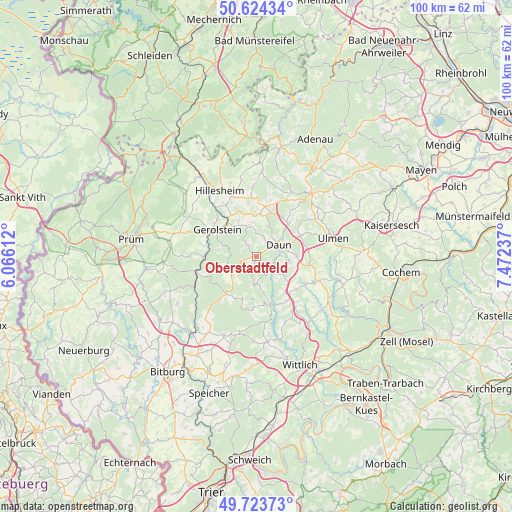
Oberstadtfeld GPS coordinates[2]
50° 10' 34.176" North, 6° 46' 9.264" East
| Map corner | latitude | longitude |
|---|---|---|
| Upper-left | 50.62434°, | 6.06612° |
| Center: | 50.17616°, | 6.76924° |
| Lower-right: | 49.72373°, | 7.47237° |
| Map W x H: | 100.1×100.1 km | = 62.2×62.2mi |
| max Lat: | 55.01917° ⇑59.5% North |
| Oberstadtfeld: | 50.17616° |
| min Lat: | ⇓40.5% South 47.40724° |
| min Long | Oberstadtfeld | max Long |
| 5.92978° | 6.76924° | 14.98853° |
| W 4.2%⇐ | ⇒95.8% E |
Elevation
Elevation of Oberstadtfeld is 418 m = 1371 ft, and this is 168.9 m = 554 ft above average elevation for this country.
| Max E: |
1256 m = 4121 ft | 22.1% |
| Oberstadtfeld | 418 m 1371 ft | |
| Avg. | 249.1 m = 817 ft | |
Min E: |
-5 m = -16 ft | 77.9% |
See also: Germany elevation on elevation.city.
Geographical zone
Oberstadtfeld is located in North temperate zone (between Tropic of Cancer and the Arctic Circle). Distance of this North polar circle is 1822.1 km =1132.2 mi to North.| Distance of | km | miles | from Oberstadtfeld |
|---|---|---|---|
| North Pole | 4428 | 2751.4 | to North |
| Arctic Circle | 1822.1 | 1132.2 | to North |
| Tropic Cancer | 2973.1 | 1847.4 | to South |
| Equator | 5579.1 | 3466.7 | to South |


Nearby cities:
15 places around Oberstadtfeld: (largest is in red/bold)
• Berlingen
7.8 km =4.8 mi,  333°
333°
• Bleckhausen
4.9 km =3 mi,  168°
168°
• Brockscheid
7.5 km =4.7 mi,  129°
129°
• Daun
4.9 km =3 mi,  61°
61°
• Hinterweiler
6.8 km =4.2 mi,  351°
351°
• Kirchweiler
6.2 km =3.9 mi,  344°
344°
• Mehren
8.2 km =5.1 mi,  84°
84°
• Neroth
2.7 km =1.7 mi,  324°
324°
• Niederstadtfeld
1.9 km =1.2 mi,  201°
201°
• Salm
6.2 km =3.9 mi,  245°
245°
• Schalkenmehren
6.6 km =4.1 mi,  100°
100°
• Schutz
5 km =3.1 mi, 196°
• Wallenborn
4.7 km =2.9 mi,  232°
232°
• Weidenbach
6.1 km =3.8 mi,  218°
218°
• Üdersdorf
3.6 km =2.2 mi,  143°
143°
Sources, notices
• [Note1] Compared only with cities in Germany existing in our database
• [Src1] Map data: © OpenStreetMap contributors (CC-BY-SA)
• [Src2] Other city data from geonames.org with taken over terms of usage.
• [Src3] Geographical zone / Annual Mean Temperature by Robert A. Rohde @ Wikipedia
