Dannenfels geodata
Dannenfels (Rheinland-Pfalz) is a seat of a fourth-order administrative division; located in Germany in Europe/Berlin (GMT+2) time zone. With population of 971 people, there are 7269 cities with bigger population in this country. Compared to other cities in Germany, 73.1% of cities are located further ↑North; 78.2% of cities are located further →East and 72.6% of cities have lower elevation than Dannenfels. Note1


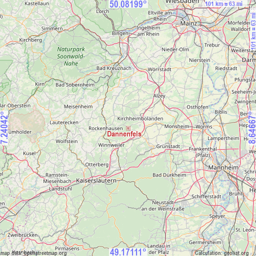
Dannenfels GPS coordinates[2]
49° 37' 43.248" North, 7° 56' 36.78" East
| Map corner | latitude | longitude |
|---|---|---|
| Upper-left | 50.08199°, | 7.24042° |
| Center: | 49.62868°, | 7.94355° |
| Lower-right: | 49.17111°, | 8.64667° |
| Map W x H: | 101.3×101.3 km | = 62.9×62.9mi |
| max Lat: | 55.01917° ⇑73.1% North |
| Dannenfels: | 49.62868° |
| min Lat: | ⇓26.9% South 47.40724° |
| min Long | Dannenfels | max Long |
| 5.92978° | 7.94355° | 14.98853° |
| W 21.8%⇐ | ⇒78.2% E |
Elevation
Elevation of Dannenfels is 379 m = 1243 ft, and this is 129.9 m = 426 ft above average elevation for this country.
| Max E: |
1256 m = 4121 ft | 27.4% |
| Dannenfels | 379 m 1243 ft | |
| Avg. | 249.1 m = 817 ft | |
Min E: |
-5 m = -16 ft | 72.6% |
See also: Germany elevation on elevation.city.
Geographical zone
Dannenfels is located in North temperate zone (between Tropic of Cancer and the Arctic Circle). Distance of this North polar circle is 1883 km =1170 mi to North.| Distance of | km | miles | from Dannenfels |
|---|---|---|---|
| North Pole | 4488.9 | 2789.3 | to North |
| Arctic Circle | 1883 | 1170 | to North |
| Tropic Cancer | 2912.3 | 1809.6 | to South |
| Equator | 5518.2 | 3428.8 | to South |


Nearby cities:
15 places around Dannenfels: (largest is in red/bold)
• Bennhausen
3.2 km =2 mi,  114°
114°
• Bolanden
5.1 km =3.2 mi,  76°
76°
• Börrstadt
5.7 km =3.5 mi,  180°
180°
• Dreisen
5.6 km =3.5 mi,  120°
120°
• Falkenstein
5.4 km =3.4 mi,  233°
233°
• Gerbach
7 km =4.3 mi,  307°
307°
• Imsbach
6.7 km =4.2 mi,  220°
220°
• Jakobsweiler
1.4 km =0.9 mi,  160°
160°
• Kirchheimbolanden
6.4 km =4 mi,  53°
53°
• Marnheim
7 km =4.3 mi,  86°
86°
• Ruppertsecken
4.9 km =3 mi,  298°
298°
• Standenbühl
4.3 km =2.7 mi,  138°
138°
• Steinbach am Donnersberg
3.2 km =2 mi,  171°
171°
• Weitersweiler
4.3 km =2.7 mi, 108°
• Würzweiler
6 km =3.7 mi,  293°
293°
Sources, notices
• [Note1] Compared only with cities in Germany existing in our database
• [Src1] Map data: © OpenStreetMap contributors (CC-BY-SA)
• [Src2] Other city data from geonames.org with taken over terms of usage.
• [Src3] Geographical zone / Annual Mean Temperature by Robert A. Rohde @ Wikipedia
