Falkenstein geodata
Falkenstein (Rheinland-Pfalz) is a seat of a fourth-order administrative division; located in Germany in Europe/Berlin (GMT+2) time zone. With population of 236 people, there are 10325 cities with bigger population in this country. Compared to other cities in Germany, 73.8% of cities are located further ↑North; 79.4% of cities are located further →East and 88.1% of cities have lower elevation than Falkenstein. Note1


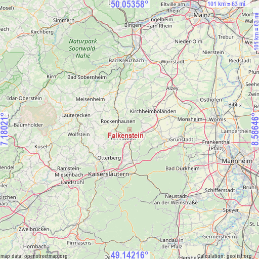
Falkenstein GPS coordinates[2]
49° 36' 0" North, 7° 52' 59.988" East
| Map corner | latitude | longitude |
|---|---|---|
| Upper-left | 50.05358°, | 7.18021° |
| Center: | 49.6°, | 7.88333° |
| Lower-right: | 49.14216°, | 8.58646° |
| Map W x H: | 101.3×101.3 km | = 62.9×62.9mi |
| max Lat: | 55.01917° ⇑73.8% North |
| Falkenstein: | 49.6° |
| min Lat: | ⇓26.2% South 47.40724° |
| min Long | Falkenstein | max Long |
| 5.92978° | 7.88333° | 14.98853° |
| W 20.6%⇐ | ⇒79.4% E |
Elevation
Elevation of Falkenstein is 494 m = 1621 ft, and this is 244.9 m = 803 ft above average elevation for this country.
| Max E: |
1256 m = 4121 ft | 11.9% |
| Falkenstein | 494 m 1621 ft | |
| Avg. | 249.1 m = 817 ft | |
Min E: |
-5 m = -16 ft | 88.1% |
See also: Germany elevation on elevation.city.
Geographical zone
Falkenstein is located in North temperate zone (between Tropic of Cancer and the Arctic Circle). Distance of this North polar circle is 1886.2 km =1172 mi to North.| Distance of | km | miles | from Falkenstein |
|---|---|---|---|
| North Pole | 4492.1 | 2791.3 | to North |
| Arctic Circle | 1886.2 | 1172 | to North |
| Tropic Cancer | 2909.1 | 1807.6 | to South |
| Equator | 5515 | 3426.9 | to South |


Nearby cities:
15 places around Falkenstein: (largest is in red/bold)
• Börrstadt
4.9 km =3 mi,  120°
120°
• Dannenfels
5.4 km =3.4 mi,  53°
53°
• Gonbach
5.7 km =3.5 mi,  167°
167°
• Imsbach
1.9 km =1.2 mi,  180°
180°
• Imsweiler
6 km =3.7 mi,  270°
270°
• Jakobsweiler
5.1 km =3.2 mi,  68°
68°
• Lohnsfeld
6.1 km =3.8 mi,  203°
203°
• Münchweiler an der Alsenz
5.6 km =3.5 mi, 180°
• Rockenhausen
5.6 km =3.5 mi,  306°
306°
• Ruppertsecken
5.6 km =3.5 mi,  0°
0°
• Schweisweiler
5.1 km =3.2 mi,  248°
248°
• Sippersfeld
6.6 km =4.1 mi,  147°
147°
• Steinbach am Donnersberg
4.8 km =3 mi,  90°
90°
• Winnweiler
4.4 km =2.7 mi,  212°
212°
• Würzweiler
5.7 km =3.5 mi,  347°
347°
Sources, notices
• [Note1] Compared only with cities in Germany existing in our database
• [Src1] Map data: © OpenStreetMap contributors (CC-BY-SA)
• [Src2] Other city data from geonames.org with taken over terms of usage.
• [Src3] Geographical zone / Annual Mean Temperature by Robert A. Rohde @ Wikipedia
