Börrstadt geodata
Börrstadt (Rheinland-Pfalz) is a seat of a fourth-order administrative division; located in Germany in Europe/Berlin (GMT+2) time zone. With population of 964 people, there are 7295 cities with bigger population in this country. Compared to other cities in Germany, 74.3% of cities are located further ↑North; 78.2% of cities are located further →East and 55.3% of cities have lower elevation than Börrstadt. Note1


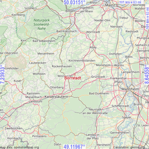
Börrstadt GPS coordinates[2]
49° 34' 39.792" North, 7° 56' 32.82" East
| Map corner | latitude | longitude |
|---|---|---|
| Upper-left | 50.03151°, | 7.23933° |
| Center: | 49.57772°, | 7.94245° |
| Lower-right: | 49.11967°, | 8.64558° |
| Map W x H: | 101.4×101.4 km | = 63×63mi |
| max Lat: | 55.01917° ⇑74.3% North |
| Börrstadt: | 49.57772° |
| min Lat: | ⇓25.7% South 47.40724° |
| min Long | Börrstadt | max Long |
| 5.92978° | 7.94245° | 14.98853° |
| W 21.8%⇐ | ⇒78.2% E |
Elevation
Elevation of Börrstadt is 260 m = 853 ft, and this is 10.9 m = 36 ft above average elevation for this country.
| Max E: |
1256 m = 4121 ft | 44.7% |
| Börrstadt | 260 m 853 ft | |
| Avg. | 249.1 m = 817 ft | |
Min E: |
-5 m = -16 ft | 55.3% |
See also: Germany elevation on elevation.city.
Geographical zone
Börrstadt is located in North temperate zone (between Tropic of Cancer and the Arctic Circle). Distance of this North polar circle is 1888.6 km =1173.5 mi to North.| Distance of | km | miles | from Börrstadt |
|---|---|---|---|
| North Pole | 4494.5 | 2792.8 | to North |
| Arctic Circle | 1888.6 | 1173.5 | to North |
| Tropic Cancer | 2906.6 | 1806.1 | to South |
| Equator | 5512.5 | 3425.3 | to South |


Nearby cities:
15 places around Börrstadt: (largest is in red/bold)
• Bennhausen
5.2 km =3.2 mi,  34°
34°
• Breunigweiler
2.1 km =1.3 mi,  125°
125°
• Dannenfels
5.7 km =3.5 mi,  0°
0°
• Dreisen
5.7 km =3.5 mi,  59°
59°
• Falkenstein
4.9 km =3 mi,  300°
300°
• Gonbach
4.3 km =2.7 mi,  224°
224°
• Imsbach
4.3 km =2.7 mi,  278°
278°
• Jakobsweiler
4.4 km =2.7 mi,  7°
7°
• Münchweiler an der Alsenz
5.3 km =3.3 mi,  234°
234°
• Ramsen
6.8 km =4.2 mi, 131°
• Sippersfeld
3.2 km =2 mi,  192°
192°
• Standenbühl
3.8 km =2.4 mi,  49°
49°
• Steinbach am Donnersberg
2.5 km =1.6 mi, 12°
• Weitersweiler
6 km =3.7 mi,  43°
43°
• Winnweiler
6.8 km =4.2 mi,  259°
259°
Sources, notices
• [Note1] Compared only with cities in Germany existing in our database
• [Src1] Map data: © OpenStreetMap contributors (CC-BY-SA)
• [Src2] Other city data from geonames.org with taken over terms of usage.
• [Src3] Geographical zone / Annual Mean Temperature by Robert A. Rohde @ Wikipedia
