Burgwindheim geodata
Burgwindheim (Bavaria) is a populated place; located in Germany in Europe/Berlin (GMT+2) time zone. With population of 1,465 people, there are 5948 cities with bigger population in this country. Compared to other cities in Germany, 68.3% of cities are located further ↑North; 60.7% of cities are located further ←West and 60.4% of cities have lower elevation than Burgwindheim. Note1
Administrative division(s):
- Level 1: Bavaria
- Level 2: Upper Franconia
- Level 3: Landkreis Bamberg
- Level 4: Burgwindheim, Markt


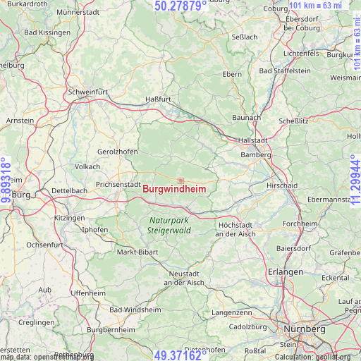
Burgwindheim GPS coordinates[2]
49° 49' 38.388" North, 10° 35' 46.716" East
| Map corner | latitude | longitude |
|---|---|---|
| Upper-left | 50.27879°, | 9.89318° |
| Center: | 49.82733°, | 10.59631° |
| Lower-right: | 49.37162°, | 11.29944° |
| Map W x H: | 100.9×100.9 km | = 62.7×62.7mi |
| max Lat: | 55.01917° ⇑68.3% North |
| Burgwindheim: | 49.82733° |
| min Lat: | ⇓31.7% South 47.40724° |
| min Long | Burgwindheim | max Long |
| 5.92978° | 10.59631° | 14.98853° |
| W 60.7%⇐ | ⇒39.3% E |
Elevation
Elevation of Burgwindheim is 292 m = 958 ft, and this is 42.9 m = 141 ft above average elevation for this country.
| Max E: |
1256 m = 4121 ft | 39.6% |
| Burgwindheim | 292 m 958 ft | |
| Avg. | 249.1 m = 817 ft | |
Min E: |
-5 m = -16 ft | 60.4% |
See also: Germany elevation on elevation.city.
Geographical zone
Burgwindheim is located in North temperate zone (between Tropic of Cancer and the Arctic Circle). Distance of this North polar circle is 1860.9 km =1156.3 mi to North.| Distance of | km | miles | from Burgwindheim |
|---|---|---|---|
| North Pole | 4466.8 | 2775.5 | to North |
| Arctic Circle | 1860.9 | 1156.3 | to North |
| Tropic Cancer | 2934.4 | 1823.4 | to South |
| Equator | 5540.3 | 3442.6 | to South |


Nearby cities:
15 places around Burgwindheim: (largest is in red/bold)
• Burgebrach
10.5 km =6.5 mi,  89°
89°
• Burghaslach
10.5 km =6.5 mi,  178°
178°
• Eltmann
16.8 km =10.4 mi,  17°
17°
• Geiselwind
10.8 km =6.7 mi,  236°
236°
• Markt Taschendorf
14.3 km =8.9 mi,  191°
191°
• Michelau
14.7 km =9.1 mi,  306°
306°
• Mühlhausen
15.2 km =9.4 mi,  122°
122°
• Oberschwarzach
13.9 km =8.6 mi,  285°
285°
• Pommersfelden
17.2 km =10.7 mi,  113°
113°
• Priesendorf
12.2 km =7.6 mi,  42°
42°
• Schlüsselfeld
8.1 km =5 mi,  168°
168°
• Vestenbergsgreuth
16 km =9.9 mi, 165°
• Viereth-Trunstadt
16.7 km =10.4 mi,  50°
50°
• Wachenroth
11.9 km =7.4 mi,  134°
134°
• Walsdorf
14.1 km =8.8 mi,  71°
71°
Sources, notices
• [Note1] Compared only with cities in Germany existing in our database
• [Src1] Map data: © OpenStreetMap contributors (CC-BY-SA)
• [Src2] Other city data from geonames.org with taken over terms of usage.
• [Src3] Geographical zone / Annual Mean Temperature by Robert A. Rohde @ Wikipedia
