Burgk geodata
Burgk (Thuringia) is a seat of a fourth-order administrative division; located in Germany in Europe/Berlin (GMT+2) time zone. With population of 102 people, there are 10829 cities with bigger population in this country. Compared to other cities in Germany, 51.5% of cities are located further ↑North; 77.5% of cities are located further ←West and 79.1% of cities have lower elevation than Burgk. Note1


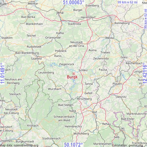
Burgk GPS coordinates[2]
50° 33' 21.708" North, 11° 43' 4.908" East
| Map corner | latitude | longitude |
|---|---|---|
| Upper-left | 51.00063°, | 11.01491° |
| Center: | 50.55603°, | 11.71803° |
| Lower-right: | 50.1072°, | 12.42116° |
| Map W x H: | 99.3×99.3 km | = 61.7×61.7mi |
| max Lat: | 55.01917° ⇑51.5% North |
| Burgk: | 50.55603° |
| min Lat: | ⇓48.5% South 47.40724° |
| min Long | Burgk | max Long |
| 5.92978° | 11.71803° | 14.98853° |
| W 77.5%⇐ | ⇒22.5% E |
Elevation
Elevation of Burgk is 428 m = 1404 ft, and this is 178.9 m = 587 ft above average elevation for this country.
| Max E: |
1256 m = 4121 ft | 20.9% |
| Burgk | 428 m 1404 ft | |
| Avg. | 249.1 m = 817 ft | |
Min E: |
-5 m = -16 ft | 79.1% |
See also: Germany elevation on elevation.city.
Geographical zone
Burgk is located in North temperate zone (between Tropic of Cancer and the Arctic Circle). Distance of this North polar circle is 1779.9 km =1106 mi to North.| Distance of | km | miles | from Burgk |
|---|---|---|---|
| North Pole | 4385.8 | 2725.2 | to North |
| Arctic Circle | 1779.9 | 1106 | to North |
| Tropic Cancer | 3015.4 | 1873.7 | to South |
| Equator | 5621.3 | 3492.9 | to South |


Nearby cities:
15 places around Burgk: (largest is in red/bold)
• Altenbeuthen
9.2 km =5.7 mi,  295°
295°
• Bucha
8.7 km =5.4 mi,  351°
351°
• Crispendorf
4.1 km =2.5 mi,  15°
15°
• Eßbach
3.9 km =2.4 mi,  321°
321°
• Görkwitz
5.5 km =3.4 mi,  56°
56°
• Keila
9.9 km =6.2 mi,  336°
336°
• Oettersdorf
8.5 km =5.3 mi,  54°
54°
• Paska
9.5 km =5.9 mi, 318°
• Plothen
9.3 km =5.8 mi, 21°
• Pörmitz
9.7 km =6 mi, 45°
• Remptendorf
5.4 km =3.4 mi,  242°
242°
• Schleiz
7 km =4.3 mi,  68°
68°
• Schöndorf
7 km =4.3 mi, 346°
• Volkmannsdorf
6.2 km =3.9 mi,  8°
8°
• Ziegenrück
7.5 km =4.7 mi, 319°
Sources, notices
• [Note1] Compared only with cities in Germany existing in our database
• [Src1] Map data: © OpenStreetMap contributors (CC-BY-SA)
• [Src2] Other city data from geonames.org with taken over terms of usage.
• [Src3] Geographical zone / Annual Mean Temperature by Robert A. Rohde @ Wikipedia
