Oettersdorf geodata
Oettersdorf (Thuringia) is a seat of a fourth-order administrative division; located in Germany in Europe/Berlin (GMT+2) time zone. With population of 877 people, there are 7609 cities with bigger population in this country. Compared to other cities in Germany, 50.6% of cities are located further ↑North; 79% of cities are located further ←West and 85.2% of cities have lower elevation than Oettersdorf. Note1


Oettersdorf GPS coordinates[2]
50° 36' 0" North, 11° 49' 0.012" East
| Map corner | latitude | longitude |
|---|---|---|
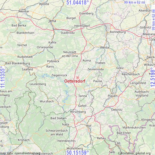
| Upper-left | 51.04418°, | 11.11355° |
| Center: | 50.6°, | 11.81667° |
| Lower-right: | 50.15159°, | 12.5198° |
| Map W x H: | 99.2×99.2 km | = 61.6×61.6mi |
| max Lat: | 55.01917° ⇑50.6% North |
| Oettersdorf: | 50.6° |
| min Lat: | ⇓49.4% South 47.40724° |
| min Long | Oettersdorf | max Long |
| 5.92978° | 11.81667° | 14.98853° |
| W 79%⇐ | ⇒21% E |
Elevation
Elevation of Oettersdorf is 471 m = 1545 ft, and this is 221.9 m = 728 ft above average elevation for this country.
| Max E: |
1256 m = 4121 ft | 14.8% |
| Oettersdorf | 471 m 1545 ft | |
| Avg. | 249.1 m = 817 ft | |
Min E: |
-5 m = -16 ft | 85.2% |
See also: Germany elevation on elevation.city.
Geographical zone
Oettersdorf is located in North temperate zone (between Tropic of Cancer and the Arctic Circle). Distance of this North polar circle is 1775 km =1102.9 mi to North.| Distance of | km | miles | from Oettersdorf |
|---|---|---|---|
| North Pole | 4380.9 | 2722.2 | to North |
| Arctic Circle | 1775 | 1102.9 | to North |
| Tropic Cancer | 3020.3 | 1876.7 | to South |
| Equator | 5626.2 | 3496 | to South |


Nearby cities:
15 places around Oettersdorf: (largest is in red/bold)
• Burgk
8.5 km =5.3 mi,  234°
234°
• Chursdorf
7.8 km =4.8 mi,  17°
17°
• Crispendorf
5.9 km =3.7 mi,  260°
260°
• Dittersdorf
5.6 km =3.5 mi,  0°
0°
• Görkwitz
3 km =1.9 mi, 231°
• Göschitz
5.1 km =3.2 mi,  43°
43°
• Kirschkau
5 km =3.1 mi,  83°
83°
• Knau
8.8 km =5.5 mi,  309°
309°
• Löhma
2.8 km =1.7 mi,  62°
62°
• Plothen
5.1 km =3.2 mi,  316°
316°
• Pörmitz
1.9 km =1.2 mi, 0°
• Schleiz
2.4 km =1.5 mi,  190°
190°
• Schöndorf
8.8 km =5.5 mi,  282°
282°
• Tegau
6.6 km =4.1 mi,  32°
32°
• Volkmannsdorf
6.1 km =3.8 mi, 281°
Sources, notices
• [Note1] Compared only with cities in Germany existing in our database
• [Src1] Map data: © OpenStreetMap contributors (CC-BY-SA)
• [Src2] Other city data from geonames.org with taken over terms of usage.
• [Src3] Geographical zone / Annual Mean Temperature by Robert A. Rohde @ Wikipedia
