Burbach geodata
Burbach (North Rhine-Westphalia) is a seat of a fourth-order administrative division; located in Germany in Europe/Berlin (GMT+2) time zone. With population of 14,942 people, there are 1068 cities with bigger population in this country. Compared to other cities in Germany, 53.4% of cities are located further ↓South; 75.8% of cities are located further →East and 69.5% of cities have lower elevation than Burbach. Note1
Administrative division(s):
- Level 1: North Rhine-Westphalia
- Level 2: Regierungsbezirk Arnsberg
- Level 3: Kreis Siegen-Wittgenstein
- Level 4: Burbach


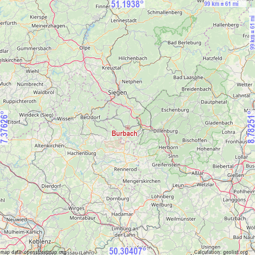
Burbach GPS coordinates[2]
50° 45' 3.78" North, 8° 4' 45.804" East
| Map corner | latitude | longitude |
|---|---|---|
| Upper-left | 51.1938°, | 7.37626° |
| Center: | 50.75105°, | 8.07939° |
| Lower-right: | 50.30407°, | 8.78251° |
| Map W x H: | 98.9×98.9 km | = 61.5×61.5mi |
| max Lat: | 55.01917° ⇑46.6% North |
| Burbach: | 50.75105° |
| min Lat: | ⇓53.4% South 47.40724° |
| min Long | Burbach | max Long |
| 5.92978° | 8.07939° | 14.98853° |
| W 24.2%⇐ | ⇒75.8% E |
Elevation
Elevation of Burbach is 355 m = 1165 ft, and this is 105.9 m = 347 ft above average elevation for this country.
| Max E: |
1256 m = 4121 ft | 30.5% |
| Burbach | 355 m 1165 ft | |
| Avg. | 249.1 m = 817 ft | |
Min E: |
-5 m = -16 ft | 69.5% |
See also: Germany elevation on elevation.city.
Geographical zone
Burbach is located in North temperate zone (between Tropic of Cancer and the Arctic Circle). Distance of this North polar circle is 1758.2 km =1092.5 mi to North.| Distance of | km | miles | from Burbach |
|---|---|---|---|
| North Pole | 4364.1 | 2711.7 | to North |
| Arctic Circle | 1758.2 | 1092.5 | to North |
| Tropic Cancer | 3037.1 | 1887.2 | to South |
| Equator | 5643 | 3506.4 | to South |


Nearby cities:
15 places around Burbach: (largest is in red/bold)
• Bretthausen
9.4 km =5.8 mi,  185°
185°
• Daaden
8.2 km =5.1 mi,  256°
256°
• Derschen
7.8 km =4.8 mi,  240°
240°
• Emmerzhausen
6.5 km =4 mi,  208°
208°
• Friedewald
9.5 km =5.9 mi, 242°
• Haiger
9.1 km =5.7 mi,  96°
96°
• Herdorf
9.3 km =5.8 mi,  288°
288°
• Liebenscheid
6.1 km =3.8 mi,  167°
167°
• Mauden
6.8 km =4.2 mi, 235°
• Neunkirchen
7.8 km =4.8 mi,  314°
314°
• Nisterberg
10.1 km =6.3 mi,  221°
221°
• Salzburg
9.6 km =6 mi, 192°
• Stein-Neukirch
8.5 km =5.3 mi, 191°
• Willingen
9.3 km =5.8 mi,  176°
176°
• Wilnsdorf
7.4 km =4.6 mi,  11°
11°
Sources, notices
• [Note1] Compared only with cities in Germany existing in our database
• [Src1] Map data: © OpenStreetMap contributors (CC-BY-SA)
• [Src2] Other city data from geonames.org with taken over terms of usage.
• [Src3] Geographical zone / Annual Mean Temperature by Robert A. Rohde @ Wikipedia
