Haiger geodata
Haiger (Hesse) is a populated place; located in Germany in Europe/Berlin (GMT+2) time zone. With population of 20,218 people, there are 764 cities with bigger population in this country. Compared to other cities in Germany, 53.1% of cities are located further ↓South; 74% of cities are located further →East and 57.5% of cities have lower elevation than Haiger. Note1
Administrative division(s):
- Level 1: Hesse
- Level 2: Regierungsbezirk Gießen
- Level 3: Lahn-Dill-Kreis
- Level 4: Haiger


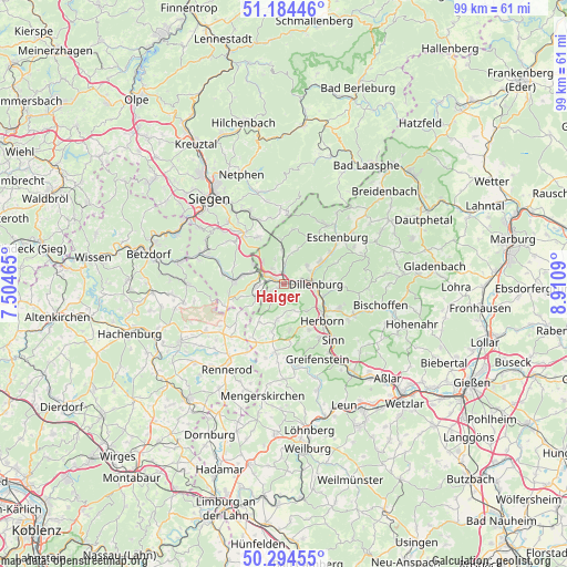
Haiger GPS coordinates[2]
50° 44' 29.832" North, 8° 12' 28.008" East
| Map corner | latitude | longitude |
|---|---|---|
| Upper-left | 51.18446°, | 7.50465° |
| Center: | 50.74162°, | 8.20778° |
| Lower-right: | 50.29455°, | 8.9109° |
| Map W x H: | 98.9×98.9 km | = 61.5×61.5mi |
| max Lat: | 55.01917° ⇑46.9% North |
| Haiger: | 50.74162° |
| min Lat: | ⇓53.1% South 47.40724° |
| min Long | Haiger | max Long |
| 5.92978° | 8.20778° | 14.98853° |
| W 26%⇐ | ⇒74% E |
Elevation
Elevation of Haiger is 275 m = 902 ft, and this is 25.9 m = 85 ft above average elevation for this country.
| Max E: |
1256 m = 4121 ft | 42.5% |
| Haiger | 275 m 902 ft | |
| Avg. | 249.1 m = 817 ft | |
Min E: |
-5 m = -16 ft | 57.5% |
See also: Germany elevation on elevation.city.
Geographical zone
Haiger is located in North temperate zone (between Tropic of Cancer and the Arctic Circle). Distance of this North polar circle is 1759.2 km =1093.1 mi to North.| Distance of | km | miles | from Haiger |
|---|---|---|---|
| North Pole | 4365.1 | 2712.3 | to North |
| Arctic Circle | 1759.2 | 1093.1 | to North |
| Tropic Cancer | 3036 | 1886.5 | to South |
| Equator | 5641.9 | 3505.7 | to South |


Nearby cities:
15 places around Haiger: (largest is in red/bold)
• Breitscheid
6.4 km =4 mi,  190°
190°
• Bretthausen
13 km =8.1 mi,  230°
230°
• Burbach
9.1 km =5.7 mi,  276°
276°
• Dillenburg
5.6 km =3.5 mi,  90°
90°
• Driedorf
12.2 km =7.6 mi, 188°
• Emmerzhausen
13.1 km =8.1 mi,  249°
249°
• Herborn
9.5 km =5.9 mi,  134°
134°
• Homberg
13.2 km =8.2 mi,  212°
212°
• Liebenscheid
9.2 km =5.7 mi,  237°
237°
• Merkenbach
11.3 km =7 mi,  147°
147°
• Mittenaar
13.2 km =8.2 mi,  110°
110°
• Sinn
13.5 km =8.4 mi,  139°
139°
• Stein-Neukirch
13 km =8.1 mi, 235°
• Willingen
11.8 km =7.3 mi, 225°
• Wilnsdorf
11.3 km =7 mi,  317°
317°
Sources, notices
• [Note1] Compared only with cities in Germany existing in our database
• [Src1] Map data: © OpenStreetMap contributors (CC-BY-SA)
• [Src2] Other city data from geonames.org with taken over terms of usage.
• [Src3] Geographical zone / Annual Mean Temperature by Robert A. Rohde @ Wikipedia
