Bernau bei Berlin geodata
Bernau bei Berlin (Brandenburg) is a populated place; located in Germany in Europe/Berlin (GMT+2) time zone. With population of 34,866 people, there are 384 cities with bigger population in this country. Compared to other cities in Germany, 79.5% of cities are located further ↓South; 96.3% of cities are located further ←West and 73% of cities have higher elevation than Bernau bei Berlin. Note1
Administrative division(s):
- Level 1: Brandenburg
- Level 3: Landkreis Barnim
- Level 4: Bernau bei Berlin


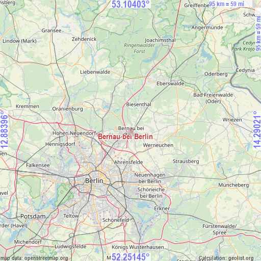
Bernau bei Berlin GPS coordinates[2]
52° 40' 47.352" North, 13° 35' 13.488" East
| Map corner | latitude | longitude |
|---|---|---|
| Upper-left | 53.10403°, | 12.88396° |
| Center: | 52.67982°, | 13.58708° |
| Lower-right: | 52.25145°, | 14.29021° |
| Map W x H: | 94.8×94.8 km | = 58.9×58.9mi |
| max Lat: | 55.01917° ⇑20.5% North |
| Bernau bei Berlin: | 52.67982° |
| min Lat: | ⇓79.5% South 47.40724° |
| min Long | Bernau bei Berl | max Long |
| 5.92978° | 13.58708° | 14.98853° |
| W 96.3%⇐ | ⇒3.7% E |
Elevation
Elevation of Bernau bei Berlin is 72 m = 236 ft, and this is 177.1 m = 581 ft below average elevation for this country.
| Max E: |
1256 m = 4121 ft | 73% |
| Avg. | 249.1 m = 817 ft | |
| Bernau bei Berlin | 72 m = 236 ft | |
Min E: |
-5 m = -16 ft | 27% |
See also: Germany elevation on elevation.city.
Geographical zone
Bernau bei Berlin is located in North temperate zone (between Tropic of Cancer and the Arctic Circle). Distance of this North polar circle is 1543.7 km =959.2 mi to North.| Distance of | km | miles | from Bernau bei Berlin |
|---|---|---|---|
| North Pole | 4149.6 | 2578.4 | to North |
| Arctic Circle | 1543.7 | 959.2 | to North |
| Tropic Cancer | 3251.5 | 2020.4 | to South |
| Equator | 5857.4 | 3639.6 | to South |


Nearby cities:
15 places around Bernau bei Berlin: (largest is in red/bold)
• Ahrensfelde
11.5 km =7.1 mi,  182°
182°
• Biesenthal
10.3 km =6.4 mi,  21°
21°
• Blankenburg
13.1 km =8.1 mi,  222°
222°
• Buch
7.9 km =4.9 mi,  230°
230°
• Falkenberg
12.7 km =7.9 mi,  192°
192°
• Französisch Buchholz
13.6 km =8.5 mi, 230°
• Karow
10.6 km =6.6 mi, 222°
• Malchow
12.8 km =8 mi,  213°
213°
• Melchow
13.4 km =8.3 mi,  36°
36°
• Neu-Hohenschönhausen
13.5 km =8.4 mi,  201°
201°
• Rüdnitz
5.3 km =3.3 mi,  28°
28°
• Stadtrandsiedlung Malchow
13 km =8.1 mi, 214°
• Wandlitz
11.1 km =6.9 mi,  308°
308°
• Wartenberg
12.6 km =7.8 mi, 202°
• Werneuchen
11.2 km =7 mi,  117°
117°
Sources, notices
• [Note1] Compared only with cities in Germany existing in our database
• [Src1] Map data: © OpenStreetMap contributors (CC-BY-SA)
• [Src2] Other city data from geonames.org with taken over terms of usage.
• [Src3] Geographical zone / Annual Mean Temperature by Robert A. Rohde @ Wikipedia
