Königsbrunn geodata
Königsbrunn (Bavaria) is a populated place; located in Germany in Europe/Berlin (GMT+2) time zone. With population of 27,494 people, there are 522 cities with bigger population in this country. Compared to other cities in Germany, 91.6% of cities are located further ↑North; 65.4% of cities are located further ←West and 90.2% of cities have lower elevation than Königsbrunn. Note1
Administrative division(s):
- Level 1: Bavaria
- Level 2: Swabia
- Level 3: Landkreis Augsburg
- Level 4: Königsbrunn


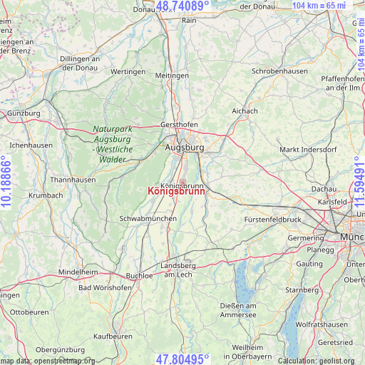
Königsbrunn GPS coordinates[2]
48° 16' 30.216" North, 10° 53' 30.408" East
| Map corner | latitude | longitude |
|---|---|---|
| Upper-left | 48.74089°, | 10.18866° |
| Center: | 48.27506°, | 10.89178° |
| Lower-right: | 47.80495°, | 11.59491° |
| Map W x H: | 104.1×104.1 km | = 64.7×64.7mi |
| max Lat: | 55.01917° ⇑91.6% North |
| Königsbrunn: | 48.27506° |
| min Lat: | ⇓8.4% South 47.40724° |
| min Long | Königsbrunn | max Long |
| 5.92978° | 10.89178° | 14.98853° |
| W 65.4%⇐ | ⇒34.6% E |
Elevation
Elevation of Königsbrunn is 516 m = 1693 ft, and this is 266.9 m = 876 ft above average elevation for this country.
| Max E: |
1256 m = 4121 ft | 9.8% |
| Königsbrunn | 516 m 1693 ft | |
| Avg. | 249.1 m = 817 ft | |
Min E: |
-5 m = -16 ft | 90.2% |
See also: Germany elevation on elevation.city.
Geographical zone
Königsbrunn is located in North temperate zone (between Tropic of Cancer and the Arctic Circle). Distance of this North polar circle is 2033.5 km =1263.6 mi to North.| Distance of | km | miles | from Königsbrunn |
|---|---|---|---|
| North Pole | 4639.4 | 2882.8 | to North |
| Arctic Circle | 2033.5 | 1263.6 | to North |
| Tropic Cancer | 2761.8 | 1716.1 | to South |
| Equator | 5367.7 | 3335.3 | to South |


Nearby cities:
15 places around Königsbrunn: (largest is in red/bold)
• Augsburg
10.7 km =6.6 mi,  2°
2°
• Bobingen
4.3 km =2.7 mi,  263°
263°
• Brunnen
7.9 km =4.9 mi,  129°
129°
• Graben
11 km =6.8 mi,  207°
207°
• Großaitingen
9.9 km =6.2 mi,  237°
237°
• Kissing
6.7 km =4.2 mi,  61°
61°
• Kleinaitingen
6.5 km =4 mi,  194°
194°
• Merching
7.6 km =4.7 mi,  115°
115°
• Mering
7 km =4.3 mi,  98°
98°
• Oberottmarshausen
4.9 km =3 mi, 211°
• Prittriching
8.7 km =5.4 mi,  162°
162°
• Schmiechen
8.5 km =5.3 mi,  139°
139°
• Stadtbergen
10.7 km =6.6 mi,  341°
341°
• Steindorf
10.3 km =6.4 mi, 129°
• Wehringen
7.3 km =4.5 mi,  247°
247°
Sources, notices
• [Note1] Compared only with cities in Germany existing in our database
• [Src1] Map data: © OpenStreetMap contributors (CC-BY-SA)
• [Src2] Other city data from geonames.org with taken over terms of usage.
• [Src3] Geographical zone / Annual Mean Temperature by Robert A. Rohde @ Wikipedia
