Oberottmarshausen geodata
Oberottmarshausen (Bavaria) is a seat of a fourth-order administrative division; located in Germany in Europe/Berlin (GMT+2) time zone. With population of 1,648 people, there are 5608 cities with bigger population in this country. Compared to other cities in Germany, 92.1% of cities are located further ↑North; 64.9% of cities are located further ←West and 91.4% of cities have lower elevation than Oberottmarshausen. Note1
Administrative division(s):
- Level 1: Bavaria
- Level 2: Swabia
- Level 3: Landkreis Augsburg
- Level 4: Oberottmarshausen


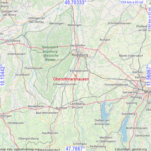
Oberottmarshausen GPS coordinates[2]
48° 14' 13.776" North, 10° 51' 27.144" East
| Map corner | latitude | longitude |
|---|---|---|
| Upper-left | 48.70333°, | 10.15442° |
| Center: | 48.23716°, | 10.85754° |
| Lower-right: | 47.7667°, | 11.56067° |
| Map W x H: | 104.1×104.1 km | = 64.7×64.7mi |
| max Lat: | 55.01917° ⇑92.1% North |
| Oberottmarshausen: | 48.23716° |
| min Lat: | ⇓7.9% South 47.40724° |
| min Long | Oberottmarshaus | max Long |
| 5.92978° | 10.85754° | 14.98853° |
| W 64.9%⇐ | ⇒35.1% E |
Elevation
Elevation of Oberottmarshausen is 533 m = 1749 ft, and this is 283.9 m = 931 ft above average elevation for this country.
| Max E: |
1256 m = 4121 ft | 8.6% |
| Oberottmarshausen | 533 m 1749 ft | |
| Avg. | 249.1 m = 817 ft | |
Min E: |
-5 m = -16 ft | 91.4% |
See also: Germany elevation on elevation.city.
Geographical zone
Oberottmarshausen is located in North temperate zone (between Tropic of Cancer and the Arctic Circle). Distance of this North polar circle is 2037.7 km =1266.2 mi to North.| Distance of | km | miles | from Oberottmarshausen |
|---|---|---|---|
| North Pole | 4643.6 | 2885.4 | to North |
| Arctic Circle | 2037.7 | 1266.2 | to North |
| Tropic Cancer | 2757.6 | 1713.5 | to South |
| Equator | 5363.5 | 3332.7 | to South |


Nearby cities:
15 places around Oberottmarshausen: (largest is in red/bold)
• Bobingen
4.1 km =2.5 mi,  334°
334°
• Brunnen
8.6 km =5.3 mi,  95°
95°
• Graben
6.1 km =3.8 mi,  205°
205°
• Großaitingen
5.9 km =3.7 mi,  259°
259°
• Kleinaitingen
2.2 km =1.4 mi,  157°
157°
• Klosterlechfeld
9.3 km =5.8 mi,  192°
192°
• Königsbrunn
4.9 km =3 mi,  31°
31°
• Merching
9.5 km =5.9 mi,  84°
84°
• Mering
9.9 km =6.2 mi,  71°
71°
• Prittriching
6.6 km =4.1 mi,  127°
127°
• Scheuring
8.2 km =5.1 mi, 159°
• Schmiechen
8.4 km =5.2 mi,  105°
105°
• Schwabmünchen
9.9 km =6.2 mi,  229°
229°
• Untermeitingen
9.3 km =5.8 mi,  203°
203°
• Wehringen
4.5 km =2.8 mi,  288°
288°
Sources, notices
• [Note1] Compared only with cities in Germany existing in our database
• [Src1] Map data: © OpenStreetMap contributors (CC-BY-SA)
• [Src2] Other city data from geonames.org with taken over terms of usage.
• [Src3] Geographical zone / Annual Mean Temperature by Robert A. Rohde @ Wikipedia
