Laubenheim geodata
Laubenheim (Rheinland-Pfalz) is a seat of a fourth-order administrative division; located in Germany in Europe/Berlin (GMT+2) time zone. With population of 844 people, there are 7728 cities with bigger population in this country. Compared to other cities in Germany, 66% of cities are located further ↑North; 79% of cities are located further →East and 70.5% of cities have higher elevation than Laubenheim. Note1
Administrative division(s):
- Level 1: Rheinland-Pfalz
- Level 3: Landkreis Bad Kreuznach
- Level 4: Laubenheim


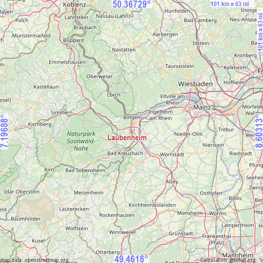
Laubenheim GPS coordinates[2]
49° 55' 0.012" North, 7° 54' 0" East
| Map corner | latitude | longitude |
|---|---|---|
| Upper-left | 50.36729°, | 7.19688° |
| Center: | 49.91667°, | 7.9° |
| Lower-right: | 49.4618°, | 8.60313° |
| Map W x H: | 100.7×100.7 km | = 62.6×62.6mi |
| max Lat: | 55.01917° ⇑66% North |
| Laubenheim: | 49.91667° |
| min Lat: | ⇓34% South 47.40724° |
| min Long | Laubenheim | max Long |
| 5.92978° | 7.9° | 14.98853° |
| W 21%⇐ | ⇒79% E |
Elevation
Elevation of Laubenheim is 88 m = 289 ft, and this is 161.1 m = 529 ft below average elevation for this country.
| Max E: |
1256 m = 4121 ft | 70.5% |
| Avg. | 249.1 m = 817 ft | |
| Laubenheim | 88 m = 289 ft | |
Min E: |
-5 m = -16 ft | 29.5% |
See also: Germany elevation on elevation.city.
Geographical zone
Laubenheim is located in North temperate zone (between Tropic of Cancer and the Arctic Circle). Distance of this North polar circle is 1851 km =1150.2 mi to North.| Distance of | km | miles | from Laubenheim |
|---|---|---|---|
| North Pole | 4456.8 | 2769.3 | to North |
| Arctic Circle | 1851 | 1150.2 | to North |
| Tropic Cancer | 2944.3 | 1829.5 | to South |
| Equator | 5550.2 | 3448.7 | to South |


Nearby cities:
15 places around Laubenheim: (largest is in red/bold)
• Biebelsheim
6.1 km =3.8 mi,  156°
156°
• Bingen am Rhein
5.6 km =3.5 mi,  359°
359°
• Bretzenheim
4.3 km =2.7 mi,  183°
183°
• Dorsheim
2.1 km =1.3 mi,  296°
296°
• Gensingen
3 km =1.9 mi,  127°
127°
• Grolsheim
1.5 km =0.9 mi, 128°
• Horrweiler
5.1 km =3.2 mi,  111°
111°
• Langenlonsheim
1.9 km =1.2 mi, 180°
• Münster-Sarmsheim
3 km =1.9 mi,  352°
352°
• Ockenheim
5.9 km =3.7 mi,  59°
59°
• Rümmelsheim
3.4 km =2.1 mi, 302°
• Waldalgesheim
6 km =3.7 mi,  307°
307°
• Waldlaubersheim
5.1 km =3.2 mi,  291°
291°
• Weiler
5.1 km =3.2 mi,  330°
330°
• Welgesheim
6 km =3.7 mi, 127°
Sources, notices
• [Note1] Compared only with cities in Germany existing in our database
• [Src1] Map data: © OpenStreetMap contributors (CC-BY-SA)
• [Src2] Other city data from geonames.org with taken over terms of usage.
• [Src3] Geographical zone / Annual Mean Temperature by Robert A. Rohde @ Wikipedia
